

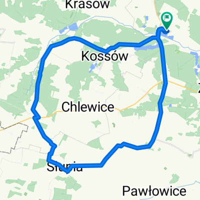
Radków 78, Radków do Radków 78, Radków
A cycling route starting in Oksa, Świętokrzyskie Voivodship, Poland.
Overview
About this route
- 57 min
- Duration
- 15.6 km
- Distance
- 124 m
- Ascent
- 119 m
- Descent
- 16.3 km/h
- Avg. speed
- 273 m
- Max. altitude

Route quality
Waytypes & surfaces along the route
Waytypes
Road
11.4 km
(73 %)
Quiet road
4.2 km
(27 %)
Surfaces
Paved
15.6 km
(100 %)
Asphalt
15.6 km
(100 %)
Continue with Bikemap
Use, edit, or download this cycling route
You would like to ride Radków 78, Radków do Radków 78, Radków or customize it for your own trip? Here is what you can do with this Bikemap route:
Free features
- Save this route as favorite or in collections
- Copy & plan your own version of this route
- Sync your route with Garmin or Wahoo
Premium features
Free trial for 3 days, or one-time payment. More about Bikemap Premium.
- Navigate this route on iOS & Android
- Export a GPX / KML file of this route
- Create your custom printout (try it for free)
- Download this route for offline navigation
Discover more Premium features.
Get Bikemap PremiumFrom our community
Other popular routes starting in Oksa
 MR W 13.2 KÓŁKO PO GMINIE Z DZIEWCZĄTKAMI
- Distance
- 19.4 km
- Ascent
- 94 m
- Descent
- 78 m
- Location
- Oksa, Świętokrzyskie Voivodship, Poland
 MR W 14.1 CIĄGNIĘCIE NA SZNUREK
- Distance
- 22.7 km
- Ascent
- 105 m
- Descent
- 104 m
- Location
- Oksa, Świętokrzyskie Voivodship, Poland
 Radków 78, Radków do Pod Krasowem, Radków
- Distance
- 3.4 km
- Ascent
- 28 m
- Descent
- 28 m
- Location
- Oksa, Świętokrzyskie Voivodship, Poland
 Radków, Radków do Radków 78, Radków
- Distance
- 12.9 km
- Ascent
- 51 m
- Descent
- 44 m
- Location
- Oksa, Świętokrzyskie Voivodship, Poland
 MR W 13.1
- Distance
- 55.4 km
- Ascent
- 120 m
- Descent
- 121 m
- Location
- Oksa, Świętokrzyskie Voivodship, Poland
 pierwsza
- Distance
- 93.6 km
- Ascent
- 418 m
- Descent
- 450 m
- Location
- Oksa, Świętokrzyskie Voivodship, Poland
 MR W 14.2 OSTATNI WYJAZD
- Distance
- 50.2 km
- Ascent
- 186 m
- Descent
- 184 m
- Location
- Oksa, Świętokrzyskie Voivodship, Poland
 MR W 13.1
- Distance
- 55.3 km
- Ascent
- 129 m
- Descent
- 129 m
- Location
- Oksa, Świętokrzyskie Voivodship, Poland
Open it in the app