
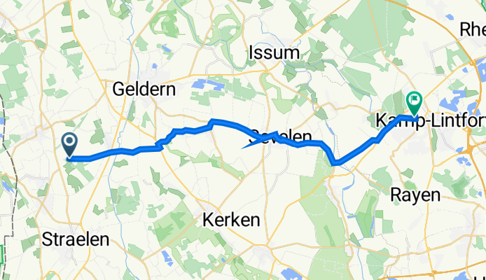
Steinstraße, Geldern nach Moerser Straße 61, Kamp-Lintfort
A cycling route starting in Straelen, North Rhine-Westphalia, Germany.
Overview
About this route
- 2 h 13 min
- Duration
- 25.8 km
- Distance
- 38 m
- Ascent
- 77 m
- Descent
- 11.6 km/h
- Avg. speed
- 74 m
- Avg. speed

Route quality
Waytypes & surfaces along the route
Waytypes
Path
15.6 km
(60 %)
Access road
3.4 km
(13 %)
Surfaces
Paved
20 km
(77 %)
Unpaved
0.2 km
(<1 %)
Asphalt
10.9 km
(42 %)
Paving stones
8.9 km
(35 %)
Continue with Bikemap
Use, edit, or download this cycling route
You would like to ride Steinstraße, Geldern nach Moerser Straße 61, Kamp-Lintfort or customize it for your own trip? Here is what you can do with this Bikemap route:
Free features
- Save this route as favorite or in collections
- Copy & plan your own version of this route
- Sync your route with Garmin or Wahoo
Premium features
Free trial for 3 days, or one-time payment. More about Bikemap Premium.
- Navigate this route on iOS & Android
- Export a GPX / KML file of this route
- Create your custom printout (try it for free)
- Download this route for offline navigation
Discover more Premium features.
Get Bikemap PremiumFrom our community
Other popular routes starting in Straelen
 Heinz,Steyl-Kald. Strae.,54Km
- Distance
- 57.2 km
- Ascent
- 147 m
- Descent
- 148 m
- Location
- Straelen, North Rhine-Westphalia, Germany
 Fahrradtour 2109
- Distance
- 19.3 km
- Ascent
- 23 m
- Descent
- 23 m
- Location
- Straelen, North Rhine-Westphalia, Germany
 Straelen nach Duisburg Tag 2
- Distance
- 46.2 km
- Ascent
- 127 m
- Descent
- 139 m
- Location
- Straelen, North Rhine-Westphalia, Germany
 Straelen-Kerken-Wachtendonk-Straelen, 30 Km
- Distance
- 29.3 km
- Ascent
- 44 m
- Descent
- 46 m
- Location
- Straelen, North Rhine-Westphalia, Germany
 Seentour
- Distance
- 19.1 km
- Ascent
- 27 m
- Descent
- 41 m
- Location
- Straelen, North Rhine-Westphalia, Germany
 Tag 2 Straelen - Roermond
- Distance
- 44 km
- Ascent
- 80 m
- Descent
- 81 m
- Location
- Straelen, North Rhine-Westphalia, Germany
 Seentour
- Distance
- 19.2 km
- Ascent
- 28 m
- Descent
- 42 m
- Location
- Straelen, North Rhine-Westphalia, Germany
 47 km vom Radwandertag 2012 Route 19
- Distance
- 45.6 km
- Ascent
- 51 m
- Descent
- 53 m
- Location
- Straelen, North Rhine-Westphalia, Germany
Open it in the app