

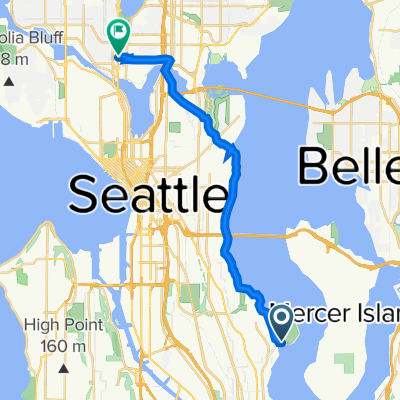
I-90 Trail, Mercer Island to 2800 Montlake Blvd E, Seattle
A cycling route starting in Mercer Island, Washington, United States.
Overview
About this route
- 2 h 13 min
- Duration
- 20 km
- Distance
- 224 m
- Ascent
- 227 m
- Descent
- 9 km/h
- Avg. speed
- 54 m
- Max. altitude

Route quality
Waytypes & surfaces along the route
Waytypes
Cycleway
10 km
(50 %)
Quiet road
3.6 km
(18 %)
Surfaces
Paved
14.4 km
(72 %)
Asphalt
8.4 km
(42 %)
Concrete
6 km
(30 %)
Undefined
5.6 km
(28 %)
Continue with Bikemap
Use, edit, or download this cycling route
You would like to ride I-90 Trail, Mercer Island to 2800 Montlake Blvd E, Seattle or customize it for your own trip? Here is what you can do with this Bikemap route:
Free features
- Save this route as favorite or in collections
- Copy & plan your own version of this route
- Sync your route with Garmin or Wahoo
Premium features
Free trial for 3 days, or one-time payment. More about Bikemap Premium.
- Navigate this route on iOS & Android
- Export a GPX / KML file of this route
- Create your custom printout (try it for free)
- Download this route for offline navigation
Discover more Premium features.
Get Bikemap PremiumFrom our community
Other popular routes starting in Mercer Island
 I-90 Trail, Mercer Island to E Mercer Way, Mercer Island
- Distance
- 27.5 km
- Ascent
- 561 m
- Descent
- 531 m
- Location
- Mercer Island, Washington, United States
 La clásica de la tarde
- Distance
- 21.9 km
- Ascent
- 228 m
- Descent
- 230 m
- Location
- Mercer Island, Washington, United States
 Lake Washington Boulevard South 5902, Seattle to Aurora Avenue North 4040, Seattle
- Distance
- 17.3 km
- Ascent
- 133 m
- Descent
- 93 m
- Location
- Mercer Island, Washington, United States
 Mercer Island to Seward Park
- Distance
- 23.3 km
- Ascent
- 218 m
- Descent
- 217 m
- Location
- Mercer Island, Washington, United States
 Courtland Place South 3652, Seattle to Courtland Place South 3652, Seattle
- Distance
- 39.2 km
- Ascent
- 470 m
- Descent
- 471 m
- Location
- Mercer Island, Washington, United States
 Courtland Place South 3637A, Seattle to 9th Avenue 1800, Seattle
- Distance
- 9.5 km
- Ascent
- 109 m
- Descent
- 90 m
- Location
- Mercer Island, Washington, United States
 Southeast 24th Street 8236, Mercer Island to South Irving Street 3443, Seattle
- Distance
- 5.1 km
- Ascent
- 70 m
- Descent
- 56 m
- Location
- Mercer Island, Washington, United States
 6/9 RIDE
- Distance
- 71.9 km
- Ascent
- 353 m
- Descent
- 353 m
- Location
- Mercer Island, Washington, United States
Open it in the app