

**07-V. Seynod - Valmorel (159,5 Km)
A cycling route starting in Seynod, Auvergne-Rhône-Alpes, France.
Overview
About this route
- -:--
- Duration
- 159.3 km
- Distance
- 4,143 m
- Ascent
- 3,296 m
- Descent
- ---
- Avg. speed
- 1,671 m
- Max. altitude
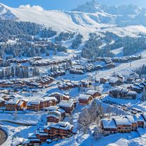
Route photos
\"")
Route quality
Waytypes & surfaces along the route
Waytypes
Busy road
115.1 km
(72 %)
Road
30.3 km
(19 %)
Surfaces
Paved
112.5 km
(71 %)
Asphalt
112.5 km
(71 %)
Undefined
46.8 km
(29 %)
Route highlights
Points of interest along the route
\"")
Point of interest after 25.2 km
CRÉT du CHÂTILLON (HC) Km 25,8 · 1.666 m
\"")
Point of interest after 63.2 km
Col du FRÈNE (3) Km 65,8 · 950 m
\"")
Point of interest after 95.5 km
Sprint ALVERTVILLE Km 96,1
\"")
Point of interest after 130.3 km
CROIX du SAUGET (HC) Km 131,5 · 1.397 m
Continue with Bikemap
Use, edit, or download this cycling route
You would like to ride **07-V. Seynod - Valmorel (159,5 Km) or customize it for your own trip? Here is what you can do with this Bikemap route:
Free features
- Save this route as favorite or in collections
- Copy & plan your own version of this route
- Split it into stages to create a multi-day tour
- Sync your route with Garmin or Wahoo
Premium features
Free trial for 3 days, or one-time payment. More about Bikemap Premium.
- Navigate this route on iOS & Android
- Export a GPX / KML file of this route
- Create your custom printout (try it for free)
- Download this route for offline navigation
Discover more Premium features.
Get Bikemap PremiumFrom our community
Other popular routes starting in Seynod
 **07-V. Seynod - Valmorel (159,5 Km)
- Distance
- 159.3 km
- Ascent
- 4,143 m
- Descent
- 3,296 m
- Location
- Seynod, Auvergne-Rhône-Alpes, France
 29 - 19 - Seynod - Mont du Chat
- Distance
- 177.9 km
- Ascent
- 4,708 m
- Descent
- 3,752 m
- Location
- Seynod, Auvergne-Rhône-Alpes, France
 12 Rue du Puits, Annecy à 12 Rue du Puits, Annecy
- Distance
- 55.6 km
- Ascent
- 1,585 m
- Descent
- 1,583 m
- Location
- Seynod, Auvergne-Rhône-Alpes, France
 bidoyon
- Distance
- 48.7 km
- Ascent
- 806 m
- Descent
- 806 m
- Location
- Seynod, Auvergne-Rhône-Alpes, France
 Tour du Lac Annecy depuis Vieugy
- Distance
- 51.8 km
- Ascent
- 539 m
- Descent
- 535 m
- Location
- Seynod, Auvergne-Rhône-Alpes, France
 gd colombier x2 + chambotte
- Distance
- 125.1 km
- Ascent
- 2,840 m
- Descent
- 2,839 m
- Location
- Seynod, Auvergne-Rhône-Alpes, France
 Long ride through Seynod
- Distance
- 38.8 km
- Ascent
- 1,151 m
- Descent
- 1,153 m
- Location
- Seynod, Auvergne-Rhône-Alpes, France
 kutas 13,14
- Distance
- 224.8 km
- Ascent
- 704 m
- Descent
- 1,176 m
- Location
- Seynod, Auvergne-Rhône-Alpes, France
Open it in the app