
GB Luzern
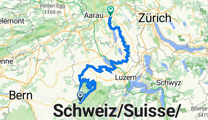
A cycling route starting in Escholzmatt, Canton of Lucerne, Switzerland.
Overview
About this route
Luzerner KulTour in drei Tagen: mit dem Veloüber die schönsten Hügelzüge der Luzerner Landregionen.
- 16 h 48 min
- Duration
- 168.4 km
- Distance
- 3,185 m
- Ascent
- 3,634 m
- Descent
- 10 km/h
- Avg. speed
- 1,104 m
- Max. altitude

Route quality
Waytypes & surfaces along the route
Waytypes
Quiet road
94 km
(56 %)
Track
41.9 km
(25 %)
Surfaces
Paved
87.2 km
(52 %)
Unpaved
23.5 km
(14 %)
Asphalt
74.9 km
(45 %)
Gravel
17.6 km
(10 %)
Continue with Bikemap
Use, edit, or download this cycling route
You would like to ride GB Luzern or customize it for your own trip? Here is what you can do with this Bikemap route:
Free features
- Save this route as favorite or in collections
- Copy & plan your own version of this route
- Split it into stages to create a multi-day tour
- Sync your route with Garmin or Wahoo
Premium features
Free trial for 3 days, or one-time payment. More about Bikemap Premium.
- Navigate this route on iOS & Android
- Export a GPX / KML file of this route
- Create your custom printout (try it for free)
- Download this route for offline navigation
Discover more Premium features.
Get Bikemap PremiumFrom our community
Other popular routes starting in Escholzmatt
 Büehl und Berg
- Distance
- 102.9 km
- Ascent
- 1,970 m
- Descent
- 2,400 m
- Location
- Escholzmatt, Canton of Lucerne, Switzerland
 Juratour: 1. Teil: Escholzmatt-Yverdon
- Distance
- 126.3 km
- Ascent
- 437 m
- Descent
- 859 m
- Location
- Escholzmatt, Canton of Lucerne, Switzerland
 Escholzmatt - Risisegg - Trubschachen - Escholzmatt
- Distance
- 23.5 km
- Ascent
- 555 m
- Descent
- 552 m
- Location
- Escholzmatt, Canton of Lucerne, Switzerland
 GB Luzerner KulTour in drei Tagen
- Distance
- 168.4 km
- Ascent
- 3,185 m
- Descent
- 3,634 m
- Location
- Escholzmatt, Canton of Lucerne, Switzerland
 Rund um den Napf
- Distance
- 86.9 km
- Ascent
- 837 m
- Descent
- 1,028 m
- Location
- Escholzmatt, Canton of Lucerne, Switzerland
 Hauptstrasse 96, Escholzmatt-Marbach nach Hauptstrasse 96, Escholzmatt-Marbach
- Distance
- 24.5 km
- Ascent
- 786 m
- Descent
- 786 m
- Location
- Escholzmatt, Canton of Lucerne, Switzerland
 Entlebuch - Thun - Fribourg
- Distance
- 29.6 km
- Ascent
- 714 m
- Descent
- 948 m
- Location
- Escholzmatt, Canton of Lucerne, Switzerland
 Escholzmatt-Glaubenbergpass-Giswil
- Distance
- 55 km
- Ascent
- 1,119 m
- Descent
- 1,479 m
- Location
- Escholzmatt, Canton of Lucerne, Switzerland
Open it in the app