

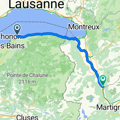
Boëge
A cycling route starting in Publier, Auvergne-Rhône-Alpes, France.
Overview
About this route
- -:--
- Duration
- 74.5 km
- Distance
- 1,191 m
- Ascent
- 1,188 m
- Descent
- ---
- Avg. speed
- 1,097 m
- Max. altitude
Route quality
Waytypes & surfaces along the route
Waytypes
Road
35 km
(47 %)
Quiet road
4.5 km
(6 %)
Surfaces
Paved
55.1 km
(74 %)
Unpaved
1.5 km
(2 %)
Asphalt
55.1 km
(74 %)
Gravel
1.5 km
(2 %)
Undefined
17.9 km
(24 %)
Continue with Bikemap
Use, edit, or download this cycling route
You would like to ride Boëge or customize it for your own trip? Here is what you can do with this Bikemap route:
Free features
- Save this route as favorite or in collections
- Copy & plan your own version of this route
- Sync your route with Garmin or Wahoo
Premium features
Free trial for 3 days, or one-time payment. More about Bikemap Premium.
- Navigate this route on iOS & Android
- Export a GPX / KML file of this route
- Create your custom printout (try it for free)
- Download this route for offline navigation
Discover more Premium features.
Get Bikemap PremiumFrom our community
Other popular routes starting in Publier
 Allinges
- Distance
- 15.8 km
- Ascent
- 178 m
- Descent
- 176 m
- Location
- Publier, Auvergne-Rhône-Alpes, France
 RdGA 2022 - Tag 1 - Variante
- Distance
- 87.9 km
- Ascent
- 2,524 m
- Descent
- 1,842 m
- Location
- Publier, Auvergne-Rhône-Alpes, France
 Hermance
- Distance
- 62.1 km
- Ascent
- 452 m
- Descent
- 449 m
- Location
- Publier, Auvergne-Rhône-Alpes, France
 Dag 13 Rondrit Thonon-les-Bains
- Distance
- 66.1 km
- Ascent
- 1,264 m
- Descent
- 1,264 m
- Location
- Publier, Auvergne-Rhône-Alpes, France
 Corsier
- Distance
- 76.8 km
- Ascent
- 640 m
- Descent
- 635 m
- Location
- Publier, Auvergne-Rhône-Alpes, France
 Lugrin
- Distance
- 37.7 km
- Ascent
- 501 m
- Descent
- 500 m
- Location
- Publier, Auvergne-Rhône-Alpes, France
 Publier
- Distance
- 34 km
- Ascent
- 298 m
- Descent
- 273 m
- Location
- Publier, Auvergne-Rhône-Alpes, France
 2 Park Dranse - Bois Noir
- Distance
- 57.7 km
- Ascent
- 245 m
- Descent
- 165 m
- Location
- Publier, Auvergne-Rhône-Alpes, France
Open it in the app