

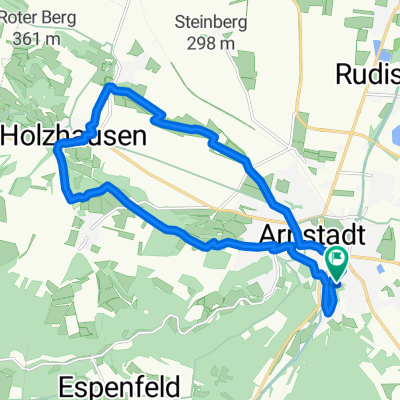
Route Arnstadt nach Arnstadt (über Ichtershausen-Molsdorf-Kornhochheim-Thörey)
A cycling route starting in Arnstadt, Thuringia, Germany.
Overview
About this route
- 1 h 3 min
- Duration
- 22.3 km
- Distance
- 103 m
- Ascent
- 156 m
- Descent
- 21.3 km/h
- Avg. speed
- 324 m
- Max. altitude

Route quality
Waytypes & surfaces along the route
Waytypes
Path
7.2 km
(32 %)
Track
6.6 km
(30 %)
Surfaces
Paved
17.6 km
(79 %)
Unpaved
3.3 km
(15 %)
Asphalt
13.1 km
(59 %)
Paving stones
2.8 km
(13 %)
Continue with Bikemap
Use, edit, or download this cycling route
You would like to ride Route Arnstadt nach Arnstadt (über Ichtershausen-Molsdorf-Kornhochheim-Thörey) or customize it for your own trip? Here is what you can do with this Bikemap route:
Free features
- Save this route as favorite or in collections
- Copy & plan your own version of this route
- Sync your route with Garmin or Wahoo
Premium features
Free trial for 3 days, or one-time payment. More about Bikemap Premium.
- Navigate this route on iOS & Android
- Export a GPX / KML file of this route
- Create your custom printout (try it for free)
- Download this route for offline navigation
Discover more Premium features.
Get Bikemap PremiumFrom our community
Other popular routes starting in Arnstadt
 Arnstadt2.gpx
- Distance
- 26.4 km
- Ascent
- 138 m
- Descent
- 137 m
- Location
- Arnstadt, Thuringia, Germany
 Bachradweg
- Distance
- 60.4 km
- Ascent
- 556 m
- Descent
- 600 m
- Location
- Arnstadt, Thuringia, Germany
 Plaue Walburgis Kloster zurück
- Distance
- 19.6 km
- Ascent
- 196 m
- Descent
- 197 m
- Location
- Arnstadt, Thuringia, Germany
 01 Geo-Route Arnstadt
- Distance
- 17.2 km
- Ascent
- 298 m
- Descent
- 301 m
- Location
- Arnstadt, Thuringia, Germany
 3Gleichen,Apfelstädt,Molsdorf,Rudisleben
- Distance
- 45.5 km
- Ascent
- 267 m
- Descent
- 268 m
- Location
- Arnstadt, Thuringia, Germany
 Arnstadt Jonastal und zurück
- Distance
- 9.9 km
- Ascent
- 151 m
- Descent
- 153 m
- Location
- Arnstadt, Thuringia, Germany
 01 Geo-Route Arnstadt
- Distance
- 17.2 km
- Ascent
- 327 m
- Descent
- 330 m
- Location
- Arnstadt, Thuringia, Germany
 Arnstadt-Rennsteig und zurück
- Distance
- 90.3 km
- Ascent
- 1,129 m
- Descent
- 1,124 m
- Location
- Arnstadt, Thuringia, Germany
Open it in the app