
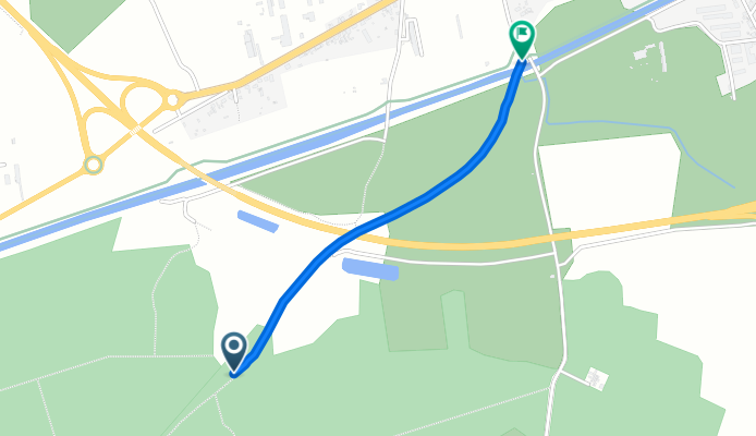
Saint-Dizier naar 20 Chemin de l’Argenté-Ligne, Saint-Dizier
A cycling route starting in Saint-Dizier, Grand Est, France.
Overview
About this route
- 3 min
- Duration
- 1.1 km
- Distance
- 0 m
- Ascent
- 12 m
- Descent
- 23 km/h
- Avg. speed
- 158 m
- Max. altitude

Continue with Bikemap
Use, edit, or download this cycling route
You would like to ride Saint-Dizier naar 20 Chemin de l’Argenté-Ligne, Saint-Dizier or customize it for your own trip? Here is what you can do with this Bikemap route:
Free features
- Save this route as favorite or in collections
- Copy & plan your own version of this route
- Sync your route with Garmin or Wahoo
Premium features
Free trial for 3 days, or one-time payment. More about Bikemap Premium.
- Navigate this route on iOS & Android
- Export a GPX / KML file of this route
- Create your custom printout (try it for free)
- Download this route for offline navigation
Discover more Premium features.
Get Bikemap PremiumFrom our community
Other popular routes starting in Saint-Dizier
 Saint-Dizier naar 20 Chemin de l’Argenté-Ligne, Saint-Dizier
- Distance
- 1.1 km
- Ascent
- 0 m
- Descent
- 12 m
- Location
- Saint-Dizier, Grand Est, France
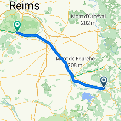
 saint dizier dijon par velo route
- Distance
- 243.4 km
- Ascent
- 430 m
- Descent
- 327 m
- Location
- Saint-Dizier, Grand Est, France
 1 D 384, Saint-Dizier naar Louvemont
- Distance
- 15.3 km
- Ascent
- 40 m
- Descent
- 36 m
- Location
- Saint-Dizier, Grand Est, France
 Saint-Dizier - Dizy
- Distance
- 97.3 km
- Ascent
- 17 m
- Descent
- 93 m
- Location
- Saint-Dizier, Grand Est, France
 6 Avenue Pierre Bérégovoy, Saint-Dizier naar 9 Place Aristide Briand, Saint-Dizier
- Distance
- 2.2 km
- Ascent
- 7 m
- Descent
- 151 m
- Location
- Saint-Dizier, Grand Est, France
 10/ Saint Dizier - za Epothemont - nocleg.
- Distance
- 37.3 km
- Ascent
- 157 m
- Descent
- 171 m
- Location
- Saint-Dizier, Grand Est, France
 063 Saint Dizier - Saint Nicolas des Port (Nancy)
- Distance
- 127.2 km
- Ascent
- 840 m
- Descent
- 782 m
- Location
- Saint-Dizier, Grand Est, France
 9e Dag Tour de France 28 Mei
- Distance
- 56.4 km
- Ascent
- 149 m
- Descent
- 81 m
- Location
- Saint-Dizier, Grand Est, France
Open it in the app