
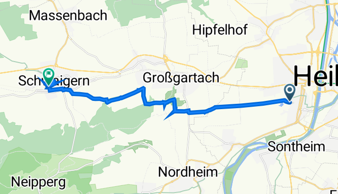
Fritz-Ulrich-Straße 43, Heilbronn nach Zeppelinstraße 40, Schwaigern
A cycling route starting in Heilbronn, Baden-Württemberg, Germany.
Overview
About this route
- 1 h 5 min
- Duration
- 12.5 km
- Distance
- 472 m
- Ascent
- 488 m
- Descent
- 11.5 km/h
- Avg. speed
- 227 m
- Avg. speed

Route quality
Waytypes & surfaces along the route
Waytypes
Quiet road
5 km
(40 %)
Track
4 km
(32 %)
Surfaces
Paved
8 km
(64 %)
Unpaved
0.8 km
(6 %)
Asphalt
7.5 km
(60 %)
Gravel
0.8 km
(6 %)
Continue with Bikemap
Use, edit, or download this cycling route
You would like to ride Fritz-Ulrich-Straße 43, Heilbronn nach Zeppelinstraße 40, Schwaigern or customize it for your own trip? Here is what you can do with this Bikemap route:
Free features
- Save this route as favorite or in collections
- Copy & plan your own version of this route
- Sync your route with Garmin or Wahoo
Premium features
Free trial for 3 days, or one-time payment. More about Bikemap Premium.
- Navigate this route on iOS & Android
- Export a GPX / KML file of this route
- Create your custom printout (try it for free)
- Download this route for offline navigation
Discover more Premium features.
Get Bikemap PremiumFrom our community
Other popular routes starting in Heilbronn
 Neipperger Runde
- Distance
- 36.4 km
- Ascent
- 355 m
- Descent
- 353 m
- Location
- Heilbronn, Baden-Württemberg, Germany
 Drei Tälertour Neckar, Kocher Jagst, Neckar
- Distance
- 63.4 km
- Ascent
- 579 m
- Descent
- 608 m
- Location
- Heilbronn, Baden-Württemberg, Germany
 Heilbronn - Geddelsbach - Dimbach - Heilbronn
- Distance
- 71.3 km
- Ascent
- 343 m
- Descent
- 328 m
- Location
- Heilbronn, Baden-Württemberg, Germany
 HN Strombergrunde 62km
- Distance
- 60.4 km
- Ascent
- 692 m
- Descent
- 667 m
- Location
- Heilbronn, Baden-Württemberg, Germany
 HN_Annasee_Stocksberger AT_Bleichsee_HW8_HN
- Distance
- 44.7 km
- Ascent
- 681 m
- Descent
- 683 m
- Location
- Heilbronn, Baden-Württemberg, Germany
 Heilbronn - Neckarwestheim - Böckingen - Heilbronn
- Distance
- 38 km
- Ascent
- 266 m
- Descent
- 265 m
- Location
- Heilbronn, Baden-Württemberg, Germany
 Kocher-Jagst-Tour Teil 1
- Distance
- 99.3 km
- Ascent
- 826 m
- Descent
- 724 m
- Location
- Heilbronn, Baden-Württemberg, Germany
 Öhr_jagsttal
- Distance
- 97.1 km
- Ascent
- 466 m
- Descent
- 472 m
- Location
- Heilbronn, Baden-Württemberg, Germany
Open it in the app