
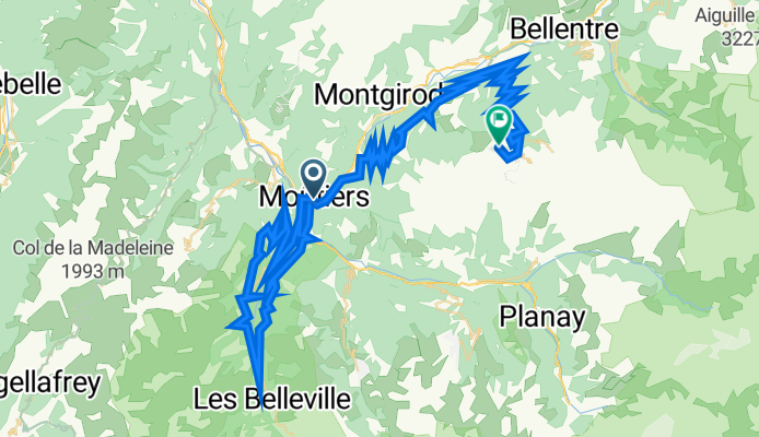
vale_Moutiers - Aime La Plagne 2000
A cycling route starting in Moûtiers, Auvergne-Rhône-Alpes, France.
Overview
About this route
- -:--
- Duration
- 86.1 km
- Distance
- 3,891 m
- Ascent
- 2,294 m
- Descent
- ---
- Avg. speed
- 2,077 m
- Max. altitude

Route quality
Waytypes & surfaces along the route
Waytypes
Road
33.6 km
(39 %)
Quiet road
12.1 km
(14 %)
Surfaces
Paved
38.7 km
(45 %)
Unpaved
2.6 km
(3 %)
Asphalt
38.7 km
(45 %)
Ground
1.7 km
(2 %)
Continue with Bikemap
Use, edit, or download this cycling route
You would like to ride vale_Moutiers - Aime La Plagne 2000 or customize it for your own trip? Here is what you can do with this Bikemap route:
Free features
- Save this route as favorite or in collections
- Copy & plan your own version of this route
- Split it into stages to create a multi-day tour
- Sync your route with Garmin or Wahoo
Premium features
Free trial for 3 days, or one-time payment. More about Bikemap Premium.
- Navigate this route on iOS & Android
- Export a GPX / KML file of this route
- Create your custom printout (try it for free)
- Download this route for offline navigation
Discover more Premium features.
Get Bikemap PremiumFrom our community
Other popular routes starting in Moûtiers
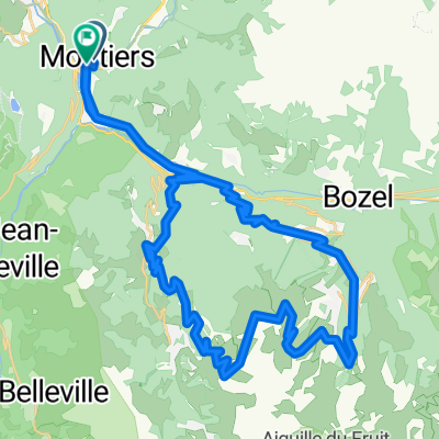 Col de la Loze - meribel
- Distance
- 55.9 km
- Ascent
- 2,547 m
- Descent
- 2,547 m
- Location
- Moûtiers, Auvergne-Rhône-Alpes, France
 vale_Moutiers - Aime La Plagne 2000
- Distance
- 86.1 km
- Ascent
- 3,891 m
- Descent
- 2,294 m
- Location
- Moûtiers, Auvergne-Rhône-Alpes, France
 Moutiers - Aime La Plagne 2000_bozza
- Distance
- 114.3 km
- Ascent
- 4,291 m
- Descent
- 4,253 m
- Location
- Moûtiers, Auvergne-Rhône-Alpes, France
 Col de la Loze, Courchevel Altiport from Moutiers
- Distance
- 62.9 km
- Ascent
- 2,277 m
- Descent
- 2,278 m
- Location
- Moûtiers, Auvergne-Rhône-Alpes, France
 Moutiers - Col du Galibier
- Distance
- 159.8 km
- Ascent
- 5,307 m
- Descent
- 3,821 m
- Location
- Moûtiers, Auvergne-Rhône-Alpes, France
 6.Etappe
- Distance
- 92.8 km
- Ascent
- 3,828 m
- Descent
- 2,149 m
- Location
- Moûtiers, Auvergne-Rhône-Alpes, France
 2017 ALPS Etapa 3 - La Madeleine
- Distance
- 123.6 km
- Ascent
- 3,161 m
- Descent
- 3,161 m
- Location
- Moûtiers, Auvergne-Rhône-Alpes, France
 Alpes 1
- Distance
- 222.5 km
- Ascent
- 6,174 m
- Descent
- 4,806 m
- Location
- Moûtiers, Auvergne-Rhône-Alpes, France
Open it in the app