

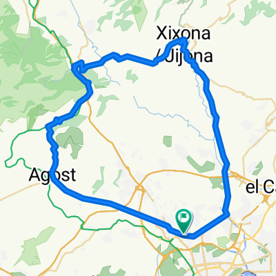
De Carretera de Agost 291, Sant Vicent del Raspeig a Calle Juan de Juanes 7, Alicante (Alacant)
A cycling route starting in San Vicent del Raspeig, Valencia, Spain.
Overview
About this route
- 10 h 40 min
- Duration
- 51 km
- Distance
- 495 m
- Ascent
- 537 m
- Descent
- 4.8 km/h
- Avg. speed
- 166 m
- Max. altitude

Route photos
\"")
Continue with Bikemap
Use, edit, or download this cycling route
You would like to ride De Carretera de Agost 291, Sant Vicent del Raspeig a Calle Juan de Juanes 7, Alicante (Alacant) or customize it for your own trip? Here is what you can do with this Bikemap route:
Free features
- Save this route as favorite or in collections
- Copy & plan your own version of this route
- Sync your route with Garmin or Wahoo
Premium features
Free trial for 3 days, or one-time payment. More about Bikemap Premium.
- Navigate this route on iOS & Android
- Export a GPX / KML file of this route
- Create your custom printout (try it for free)
- Download this route for offline navigation
Discover more Premium features.
Get Bikemap PremiumFrom our community
Other popular routes starting in San Vicent del Raspeig
 VIA VERDE MAIGMO DESDE SAN VICENTE DEL RASPEIG
- Distance
- 44.2 km
- Ascent
- 527 m
- Descent
- 527 m
- Location
- San Vicent del Raspeig, Valencia, Spain
 Llegada Marcha Cicloturista Ciudad de San Vicente
- Distance
- 3.9 km
- Ascent
- 10 m
- Descent
- 60 m
- Location
- San Vicent del Raspeig, Valencia, Spain
 RUTA SAN VICENTE-SABINAR-MONEGRE-SAN VICENTE
- Distance
- 31.4 km
- Ascent
- 459 m
- Descent
- 458 m
- Location
- San Vicent del Raspeig, Valencia, Spain
 SAN VICENTE - JIJONA - TIBI - AGOST- SAN VICENTE
- Distance
- 62.8 km
- Ascent
- 845 m
- Descent
- 849 m
- Location
- San Vicent del Raspeig, Valencia, Spain
 San Vicente-Campello-Aguas-Pantano Amadorio-Orxeta-Finestrat-Villajoyosa-Orxeta-Relleu-Aguas-Busot-Muchamiel-San Vicente
- Distance
- 111.5 km
- Ascent
- 1,123 m
- Descent
- 1,122 m
- Location
- San Vicent del Raspeig, Valencia, Spain
 ALICANTE-TUDONS-ALICANTE
- Distance
- 124.2 km
- Ascent
- 1,741 m
- Descent
- 1,741 m
- Location
- San Vicent del Raspeig, Valencia, Spain
 alicante geiser
- Distance
- 32.5 km
- Ascent
- 621 m
- Descent
- 596 m
- Location
- San Vicent del Raspeig, Valencia, Spain
 ruta sanve :)
- Distance
- 15.3 km
- Ascent
- 90 m
- Descent
- 88 m
- Location
- San Vicent del Raspeig, Valencia, Spain
Open it in the app