

Tour4D Kautenbach-Bastogne-Wiltz
A cycling route starting in Wilwerwiltz, District de Diekirch, Luxembourg.
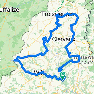
Overview
About this route
- 3 h 47 min
- Duration
- 50.4 km
- Distance
- 0 m
- Ascent
- 0 m
- Descent
- 13.3 km/h
- Avg. speed
- 0 m
- Max. altitude

Route quality
Waytypes & surfaces along the route
Waytypes
Cycleway
32.5 km
(64 %)
Track
8.1 km
(16 %)
Surfaces
Paved
48.8 km
(97 %)
Asphalt
41 km
(81 %)
Concrete
6.8 km
(13 %)
Continue with Bikemap
Use, edit, or download this cycling route
You would like to ride Tour4D Kautenbach-Bastogne-Wiltz or customize it for your own trip? Here is what you can do with this Bikemap route:
Free features
- Save this route as favorite or in collections
- Copy & plan your own version of this route
- Sync your route with Garmin or Wahoo
Premium features
Free trial for 3 days, or one-time payment. More about Bikemap Premium.
- Navigate this route on iOS & Android
- Export a GPX / KML file of this route
- Create your custom printout (try it for free)
- Download this route for offline navigation
Discover more Premium features.
Get Bikemap PremiumFrom our community
Other popular routes starting in Wilwerwiltz
 PC 21 - Cycle path du Nord: Kautenbach-Wilwerwiltz
- Distance
- 9.8 km
- Ascent
- 410 m
- Descent
- 354 m
- Location
- Wilwerwiltz, District de Diekirch, Luxembourg
 Wilwerwiltz/Benonchamp/Wilwerwiltz
- Distance
- 53.1 km
- Ascent
- 523 m
- Descent
- 524 m
- Location
- Wilwerwiltz, District de Diekirch, Luxembourg
 jardins à suivre+Wëntger Gënzentour+PC20
- Distance
- 100.8 km
- Ascent
- 786 m
- Descent
- 782 m
- Location
- Wilwerwiltz, District de Diekirch, Luxembourg
 Vallée de l'Our
- Distance
- 44.1 km
- Ascent
- 795 m
- Descent
- 733 m
- Location
- Wilwerwiltz, District de Diekirch, Luxembourg
 PC22.
PC22.- Distance
- 26.9 km
- Ascent
- 370 m
- Descent
- 452 m
- Location
- Wilwerwiltz, District de Diekirch, Luxembourg
 e@EPMC - 1c - elisabeth goes EPMC - étape Kautenbach-Goebelsmühle
- Distance
- 14.6 km
- Ascent
- 347 m
- Descent
- 326 m
- Location
- Wilwerwiltz, District de Diekirch, Luxembourg
 Wiltz Cycle Path (PC 20)
- Distance
- 24.9 km
- Ascent
- 786 m
- Descent
- 622 m
- Location
- Wilwerwiltz, District de Diekirch, Luxembourg
 Tag 3 Ardenne - Eifel 2014 Alschied - Roetgen 143km
- Distance
- 142.6 km
- Ascent
- 588 m
- Descent
- 439 m
- Location
- Wilwerwiltz, District de Diekirch, Luxembourg
Open it in the app