

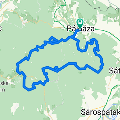
18.6 TOURING Pálháza-Pusztaf-Füzér-Aszfalt
A cycling route starting in Sátoraljaújhely, Borsod-Abauj Zemplen county, Hungary.
Overview
About this route
- -:--
- Duration
- 16.7 km
- Distance
- 361 m
- Ascent
- 81 m
- Descent
- ---
- Avg. speed
- 446 m
- Max. altitude

Route quality
Waytypes & surfaces along the route
Waytypes
Road
7.2 km
(43 %)
Quiet road
3.5 km
(21 %)
Surfaces
Paved
8.5 km
(51 %)
Unpaved
0.7 km
(4 %)
Asphalt
8.5 km
(51 %)
Gravel
0.7 km
(4 %)
Undefined
7.5 km
(45 %)
Continue with Bikemap
Use, edit, or download this cycling route
You would like to ride 18.6 TOURING Pálháza-Pusztaf-Füzér-Aszfalt or customize it for your own trip? Here is what you can do with this Bikemap route:
Free features
- Save this route as favorite or in collections
- Copy & plan your own version of this route
- Sync your route with Garmin or Wahoo
Premium features
Free trial for 3 days, or one-time payment. More about Bikemap Premium.
- Navigate this route on iOS & Android
- Export a GPX / KML file of this route
- Create your custom printout (try it for free)
- Download this route for offline navigation
Discover more Premium features.
Get Bikemap PremiumFrom our community
Other popular routes starting in Sátoraljaújhely
 48.471, 21.519 - 48.379, 21.434
- Distance
- 18.4 km
- Ascent
- 309 m
- Descent
- 198 m
- Location
- Sátoraljaújhely, Borsod-Abauj Zemplen county, Hungary
 District of Trebišov - District of Košice I
- Distance
- 71.1 km
- Ascent
- 485 m
- Descent
- 376 m
- Location
- Sátoraljaújhely, Borsod-Abauj Zemplen county, Hungary
 STEREO_Pálháza Szalánc vára
- Distance
- 27.1 km
- Ascent
- 744 m
- Descent
- 469 m
- Location
- Sátoraljaújhely, Borsod-Abauj Zemplen county, Hungary
 STEREO PRÓBA 2023
- Distance
- 84.8 km
- Ascent
- 2,514 m
- Descent
- 2,514 m
- Location
- Sátoraljaújhely, Borsod-Abauj Zemplen county, Hungary
 Zemplény 2
- Distance
- 55.2 km
- Ascent
- 667 m
- Descent
- 668 m
- Location
- Sátoraljaújhely, Borsod-Abauj Zemplen county, Hungary
 Sport utca, Pálháza - Sport utca, Pálháza
- Distance
- 26.5 km
- Ascent
- 789 m
- Descent
- 787 m
- Location
- Sátoraljaújhely, Borsod-Abauj Zemplen county, Hungary
 Ipartelep utca, Pálháza to Szemlőhegyi út, Bózsva
- Distance
- 2.8 km
- Ascent
- 186 m
- Descent
- 171 m
- Location
- Sátoraljaújhely, Borsod-Abauj Zemplen county, Hungary
 STEREO KIPRÓBÁLVA 2023
- Distance
- 40.8 km
- Ascent
- 892 m
- Descent
- 893 m
- Location
- Sátoraljaújhely, Borsod-Abauj Zemplen county, Hungary
Open it in the app