

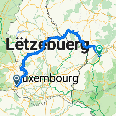
Saint-Leger_49km
A cycling route starting in Aubange, Wallonia, Belgium.
Overview
About this route
- -:--
- Duration
- 48.9 km
- Distance
- 767 m
- Ascent
- 763 m
- Descent
- ---
- Avg. speed
- 388 m
- Max. altitude

Route quality
Waytypes & surfaces along the route
Waytypes
Quiet road
17.5 km
(36 %)
Busy road
16.2 km
(33 %)
Surfaces
Paved
20.9 km
(43 %)
Unpaved
0 km
(<1 %)
Asphalt
20.4 km
(42 %)
Paved (undefined)
0.5 km
(1 %)
Continue with Bikemap
Use, edit, or download this cycling route
You would like to ride Saint-Leger_49km or customize it for your own trip? Here is what you can do with this Bikemap route:
Free features
- Save this route as favorite or in collections
- Copy & plan your own version of this route
- Sync your route with Garmin or Wahoo
Premium features
Free trial for 3 days, or one-time payment. More about Bikemap Premium.
- Navigate this route on iOS & Android
- Export a GPX / KML file of this route
- Create your custom printout (try it for free)
- Download this route for offline navigation
Discover more Premium features.
Get Bikemap PremiumFrom our community
Other popular routes starting in Aubange
 Messancy-Virton-Messancy 73km 800HM
- Distance
- 72.8 km
- Ascent
- 892 m
- Descent
- 892 m
- Location
- Aubange, Wallonia, Belgium
 depart de mont Saint Martin 13/07
- Distance
- 3,853.7 km
- Ascent
- 6,256 m
- Descent
- 5,096 m
- Location
- Aubange, Wallonia, Belgium
 CT part 1
- Distance
- 267.9 km
- Ascent
- 450 m
- Descent
- 489 m
- Location
- Aubange, Wallonia, Belgium
 Skatepark Pétange
- Distance
- 5.1 km
- Ascent
- 23 m
- Descent
- 23 m
- Location
- Aubange, Wallonia, Belgium
 V BE AVS Aix-sur-Cloie Baranzy Meix
- Distance
- 24.7 km
- Ascent
- 263 m
- Descent
- 263 m
- Location
- Aubange, Wallonia, Belgium
 Laser-Ettelbruck-Trier 115km 1k3HM
- Distance
- 114.5 km
- Ascent
- 1,607 m
- Descent
- 1,762 m
- Location
- Aubange, Wallonia, Belgium
 Laser-Lëllgen_Laser_160
- Distance
- 161.8 km
- Ascent
- 2,418 m
- Descent
- 2,417 m
- Location
- Aubange, Wallonia, Belgium
 Saint-Leger_49km
- Distance
- 49.1 km
- Ascent
- 564 m
- Descent
- 556 m
- Location
- Aubange, Wallonia, Belgium
Open it in the app