

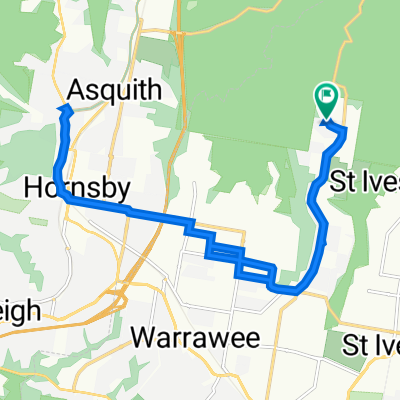
St Ives - Gledhill WF - Churchpoint - Ingleside
A cycling route starting in North Turramurra, New South Wales, Australia.
Overview
About this route
St Ives library - Upper Gledhill Water Fall - Churchpoint Waterfront cafe - Ingleside ( Monica Dog rescue) - Tempo Coffee - St Ives
- -:--
- Duration
- 41.8 km
- Distance
- 678 m
- Ascent
- 677 m
- Descent
- ---
- Avg. speed
- 220 m
- Max. altitude

Route quality
Waytypes & surfaces along the route
Waytypes
Cycleway
15.9 km
(38 %)
Quiet road
9.6 km
(23 %)
Surfaces
Paved
40.5 km
(97 %)
Paved (undefined)
30.9 km
(74 %)
Asphalt
9.6 km
(23 %)
Undefined
1.3 km
(3 %)
Continue with Bikemap
Use, edit, or download this cycling route
You would like to ride St Ives - Gledhill WF - Churchpoint - Ingleside or customize it for your own trip? Here is what you can do with this Bikemap route:
Free features
- Save this route as favorite or in collections
- Copy & plan your own version of this route
- Sync your route with Garmin or Wahoo
Premium features
Free trial for 3 days, or one-time payment. More about Bikemap Premium.
- Navigate this route on iOS & Android
- Export a GPX / KML file of this route
- Create your custom printout (try it for free)
- Download this route for offline navigation
Discover more Premium features.
Get Bikemap PremiumFrom our community
Other popular routes starting in North Turramurra
 Wahroonga/Kuring-gai Loop
- Distance
- 25.5 km
- Ascent
- 327 m
- Descent
- 327 m
- Location
- North Turramurra, New South Wales, Australia
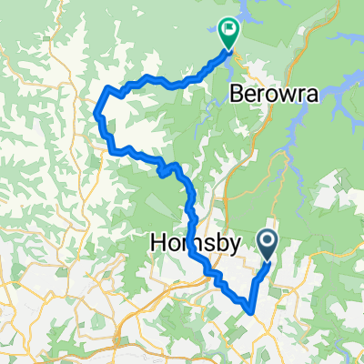 Turamurra to Berowra
- Distance
- 35.6 km
- Ascent
- 366 m
- Descent
- 530 m
- Location
- North Turramurra, New South Wales, Australia
 Bobbo 2022 - Bobbo 2022
- Distance
- 77.3 km
- Ascent
- 1,266 m
- Descent
- 1,267 m
- Location
- North Turramurra, New South Wales, Australia
 OTWS 2015 Section 5
- Distance
- 12.9 km
- Ascent
- 345 m
- Descent
- 349 m
- Location
- North Turramurra, New South Wales, Australia
 St Ives - Gledhill WF - Churchpoint - Ingleside
- Distance
- 41.8 km
- Ascent
- 678 m
- Descent
- 677 m
- Location
- North Turramurra, New South Wales, Australia
 24 Du Faur St, North Turramurra to 24 Du Faur St, North Turramurra
- Distance
- 21 km
- Ascent
- 252 m
- Descent
- 255 m
- Location
- North Turramurra, New South Wales, Australia
 Bobbo 27km 2022
- Distance
- 26.7 km
- Ascent
- 446 m
- Descent
- 447 m
- Location
- North Turramurra, New South Wales, Australia
 far fire track
- Distance
- 9.4 km
- Ascent
- 71 m
- Descent
- 67 m
- Location
- North Turramurra, New South Wales, Australia
Open it in the app