
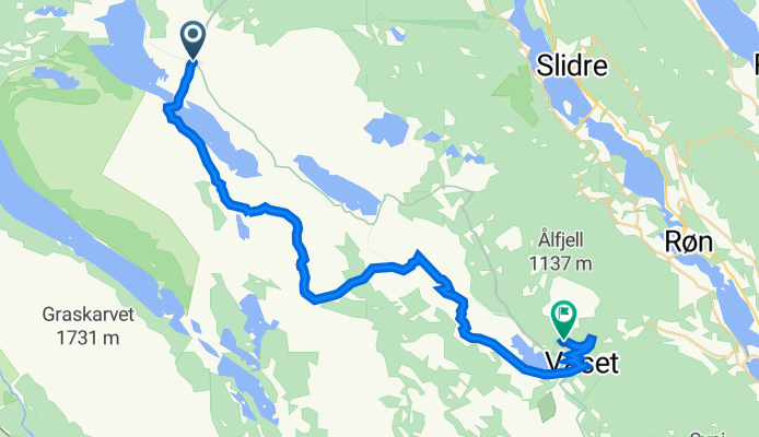
Midtre Syndin 1, Ryfoss to Ålfjellvegen 185, Røn
A cycling route starting in Vang, Oppland, Norway.
Overview
About this route
- 2 h 14 min
- Duration
- 28.6 km
- Distance
- 443 m
- Ascent
- 449 m
- Descent
- 12.8 km/h
- Avg. speed
- 1,041 m
- Max. altitude

Route quality
Waytypes & surfaces along the route
Waytypes
Quiet road
20.9 km
(73 %)
Track
4 km
(14 %)
Surfaces
Unpaved
19.7 km
(69 %)
Gravel
15.4 km
(54 %)
Ground
4.3 km
(15 %)
Undefined
8.9 km
(31 %)
Continue with Bikemap
Use, edit, or download this cycling route
You would like to ride Midtre Syndin 1, Ryfoss to Ålfjellvegen 185, Røn or customize it for your own trip? Here is what you can do with this Bikemap route:
Free features
- Save this route as favorite or in collections
- Copy & plan your own version of this route
- Sync your route with Garmin or Wahoo
Premium features
Free trial for 3 days, or one-time payment. More about Bikemap Premium.
- Navigate this route on iOS & Android
- Export a GPX / KML file of this route
- Create your custom printout (try it for free)
- Download this route for offline navigation
Discover more Premium features.
Get Bikemap PremiumFrom our community
Other popular routes starting in Vang
 Vang - Beitostølen - Vang
- Distance
- 89.2 km
- Ascent
- 1,209 m
- Descent
- 1,211 m
- Location
- Vang, Oppland, Norway
 Vang - Sogndal
- Distance
- 122.7 km
- Ascent
- 2,427 m
- Descent
- 2,884 m
- Location
- Vang, Oppland, Norway
 Vang - Skakadalen - Smådalen - Helin - Vang
- Distance
- 50.5 km
- Ascent
- 1,221 m
- Descent
- 1,221 m
- Location
- Vang, Oppland, Norway
 Helinrunden XL
- Distance
- 61.5 km
- Ascent
- 1,093 m
- Descent
- 1,093 m
- Location
- Vang, Oppland, Norway
 Lomen-Hensåsen
- Distance
- 33 km
- Ascent
- 529 m
- Descent
- 529 m
- Location
- Vang, Oppland, Norway
 Syndinstøga - Gol
- Distance
- 77.4 km
- Ascent
- 902 m
- Descent
- 1,680 m
- Location
- Vang, Oppland, Norway
 Syndin - Vaset
- Distance
- 22.4 km
- Ascent
- 296 m
- Descent
- 314 m
- Location
- Vang, Oppland, Norway
 Mjølkevegen dag 5, Laglim badesø_hytte
- Distance
- 29.9 km
- Ascent
- 808 m
- Descent
- 448 m
- Location
- Vang, Oppland, Norway
Open it in the app