

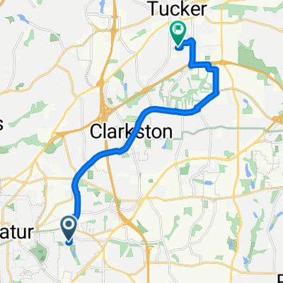
175 N Arcadia Ave, Decatur to 1743 Hudson Woods Trail, Decatur
A cycling route starting in Avondale Estates, Georgia, United States.
Overview
About this route
- 53 min
- Duration
- 9.6 km
- Distance
- 97 m
- Ascent
- 115 m
- Descent
- 10.9 km/h
- Avg. speed
- 326 m
- Max. altitude
Route quality
Waytypes & surfaces along the route
Waytypes
Road
3.2 km
(33 %)
Cycleway
3.1 km
(32 %)
Surfaces
Paved
4.3 km
(45 %)
Concrete
2.6 km
(27 %)
Paved (undefined)
1.5 km
(16 %)
Continue with Bikemap
Use, edit, or download this cycling route
You would like to ride 175 N Arcadia Ave, Decatur to 1743 Hudson Woods Trail, Decatur or customize it for your own trip? Here is what you can do with this Bikemap route:
Free features
- Save this route as favorite or in collections
- Copy & plan your own version of this route
- Sync your route with Garmin or Wahoo
Premium features
Free trial for 3 days, or one-time payment. More about Bikemap Premium.
- Navigate this route on iOS & Android
- Export a GPX / KML file of this route
- Create your custom printout (try it for free)
- Download this route for offline navigation
Discover more Premium features.
Get Bikemap PremiumFrom our community
Other popular routes starting in Avondale Estates
 Durham Circle 4296, Stone Mountain to Phillips Road 1691, Lithonia
- Distance
- 9.3 km
- Ascent
- 109 m
- Descent
- 104 m
- Location
- Avondale Estates, Georgia, United States
 Decatur-Oakhurst
- Distance
- 10.7 km
- Ascent
- 77 m
- Descent
- 85 m
- Location
- Avondale Estates, Georgia, United States
 Berkeley Rd, Avondale Estates to Avis Ln, Tucker
- Distance
- 14.3 km
- Ascent
- 113 m
- Descent
- 111 m
- Location
- Avondale Estates, Georgia, United States
 33.771, -84.266 to 33.734, -84.365
- Distance
- 14.5 km
- Ascent
- 133 m
- Descent
- 147 m
- Location
- Avondale Estates, Georgia, United States
 Steady ride in Avondale Estates
- Distance
- 11.6 km
- Ascent
- 150 m
- Descent
- 120 m
- Location
- Avondale Estates, Georgia, United States
 175 N Arcadia Ave, Decatur to 1743 Hudson Woods Trail, Decatur
- Distance
- 9.6 km
- Ascent
- 97 m
- Descent
- 115 m
- Location
- Avondale Estates, Georgia, United States
 Berkeley Rd, Avondale Estates to Main St, Stone Mountain
- Distance
- 14 km
- Ascent
- 76 m
- Descent
- 76 m
- Location
- Avondale Estates, Georgia, United States
 2787–2795 E Ponce de Leon Ave, Decatur to 1070 Forrest Ave, Stone Mountain
- Distance
- 12.7 km
- Ascent
- 145 m
- Descent
- 143 m
- Location
- Avondale Estates, Georgia, United States
Open it in the app