

Telgárt - Mlynky - Nálepkovo - Gelnica - Margecany - Košice
A cycling route starting in Dobšiná, Košice Region, Slovakia.
Overview
About this route
In direction from Telgárt to Košice it is mostly downhill (with one over 50kmalmost uninerupted downhill) alongside the railway on not very heavili used roads. Most of the road is paved, but there are sections where at least cross bike is required. Road bikes Cannot use roads Mlynky-Nálepkovo and Margecany-Ružín.
- -:--
- Duration
- 139.9 km
- Distance
- 2,169 m
- Ascent
- 2,837 m
- Descent
- ---
- Avg. speed
- 999 m
- Max. altitude

Route quality
Waytypes & surfaces along the route
Waytypes
Road
35 km
(25 %)
Track
15.4 km
(11 %)
Surfaces
Paved
60.2 km
(43 %)
Unpaved
11.2 km
(8 %)
Asphalt
56 km
(40 %)
Gravel
7 km
(5 %)
Continue with Bikemap
Use, edit, or download this cycling route
You would like to ride Telgárt - Mlynky - Nálepkovo - Gelnica - Margecany - Košice or customize it for your own trip? Here is what you can do with this Bikemap route:
Free features
- Save this route as favorite or in collections
- Copy & plan your own version of this route
- Split it into stages to create a multi-day tour
- Sync your route with Garmin or Wahoo
Premium features
Free trial for 3 days, or one-time payment. More about Bikemap Premium.
- Navigate this route on iOS & Android
- Export a GPX / KML file of this route
- Create your custom printout (try it for free)
- Download this route for offline navigation
Discover more Premium features.
Get Bikemap PremiumFrom our community
Other popular routes starting in Dobšiná
 Zelená stuha Horehronia
- Distance
- 54.8 km
- Ascent
- 979 m
- Descent
- 1,246 m
- Location
- Dobšiná, Košice Region, Slovakia
 Telgárt, Telgárt až Muráň
- Distance
- 21.6 km
- Ascent
- 667 m
- Descent
- 694 m
- Location
- Dobšiná, Košice Region, Slovakia
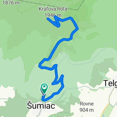 Kráľova Hoľa
- Distance
- 23.8 km
- Ascent
- 1,024 m
- Descent
- 1,009 m
- Location
- Dobšiná, Košice Region, Slovakia
 Dedinky - Stratená - Stratenský kaňon - Dobšinská Maša - Dedinky CLONED FROM ROUTE 582102
- Distance
- 14.3 km
- Ascent
- 449 m
- Descent
- 445 m
- Location
- Dobšiná, Košice Region, Slovakia
 Telgart- Dobšiná- Dobš. ľad jask- Telgárt
- Distance
- 51.8 km
- Ascent
- 1,029 m
- Descent
- 1,039 m
- Location
- Dobšiná, Košice Region, Slovakia
 KH-Certovica
- Distance
- 42 km
- Ascent
- 1,110 m
- Descent
- 1,803 m
- Location
- Dobšiná, Košice Region, Slovakia
 Šumiac, Kráľová Hoľa, Bartková,Pohorelá Šumiac
- Distance
- 39.1 km
- Ascent
- 1,338 m
- Descent
- 1,337 m
- Location
- Dobšiná, Košice Region, Slovakia
 MTB MARATON MLYNKY 2012
- Distance
- 61.5 km
- Ascent
- 0 m
- Descent
- 0 m
- Location
- Dobšiná, Košice Region, Slovakia
Open it in the app