

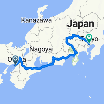
Easy ride
A cycling route starting in Sakai, Osaka, Japan.
Overview
About this route
- 2 h 3 min
- Duration
- 38.8 km
- Distance
- 162 m
- Ascent
- 126 m
- Descent
- 18.9 km/h
- Avg. speed
- 87 m
- Max. altitude

Route quality
Waytypes & surfaces along the route
Waytypes
Quiet road
18.6 km
(48 %)
Pedestrian area
9.7 km
(25 %)
Surfaces
Paved
15.5 km
(40 %)
Asphalt
12.4 km
(32 %)
Paved (undefined)
3.1 km
(8 %)
Undefined
23.3 km
(60 %)
Continue with Bikemap
Use, edit, or download this cycling route
You would like to ride Easy ride or customize it for your own trip? Here is what you can do with this Bikemap route:
Free features
- Save this route as favorite or in collections
- Copy & plan your own version of this route
- Sync your route with Garmin or Wahoo
Premium features
Free trial for 3 days, or one-time payment. More about Bikemap Premium.
- Navigate this route on iOS & Android
- Export a GPX / KML file of this route
- Create your custom printout (try it for free)
- Download this route for offline navigation
Discover more Premium features.
Get Bikemap PremiumFrom our community
Other popular routes starting in Sakai
 散走:2つの歴史ドラマに出会う
- Distance
- 8.3 km
- Ascent
- 68 m
- Descent
- 69 m
- Location
- Sakai, Osaka, Japan
 大山公園「伸庵」呈茶コース
- Distance
- 8.5 km
- Ascent
- 34 m
- Descent
- 42 m
- Location
- Sakai, Osaka, Japan
 紐解けば堺 サンプルルート
- Distance
- 10.4 km
- Ascent
- 60 m
- Descent
- 70 m
- Location
- Sakai, Osaka, Japan
 japan
japan- Distance
- 975 km
- Ascent
- 5,309 m
- Descent
- 5,294 m
- Location
- Sakai, Osaka, Japan
 環濠クルーズコース
- Distance
- 7.4 km
- Ascent
- 5 m
- Descent
- 15 m
- Location
- Sakai, Osaka, Japan
 Osaka to Fukuoka
- Distance
- 776.2 km
- Ascent
- 1,117 m
- Descent
- 1,105 m
- Location
- Sakai, Osaka, Japan
 Tour of Japan 2014 Prologue
- Distance
- 2.8 km
- Ascent
- 15 m
- Descent
- 12 m
- Location
- Sakai, Osaka, Japan
 浅香ツツジ→堺駅
- Distance
- 5.6 km
- Ascent
- 10 m
- Descent
- 12 m
- Location
- Sakai, Osaka, Japan
Open it in the app