Belchen-Haldenhof_60km_1600hm
- 61.4 km
- 1,523 m
- 1,523 m
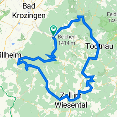
- Münstertal, Black Forest, Baden-Wurttemberg, Germany
A cycling route starting in Münstertal, Black Forest, Baden-Wurttemberg, Germany.
Overview
Start in Münstertal, Kreuzwegpass 1080m, Badenweiler, Hochblauen 1160m, Tegernau, Gresgen 700m, Atzenbach, Häg, Ehrsberg 910m, Wernbach, Schönau, Utzenfeld, Todtnau, Notschrei 1120m, Schauinsland 1200m, über die Stohrenstraße zurück nach Münsteral.
Kreuzweg 11,8 km 700 hm, Hochblauen 7,6 km 660 hm, Gresgen 3,3 km 260 hm, Ehrsberg 4,6 km 280 hm, Notschrei 7,5 km 480 hm, Schauinsland 3,5 km 60 hm.
created this 2 years ago
Route quality
Road
22.1 km
(20 %)
Quiet road
11 km
(10 %)
Paved
83.9 km
(76 %)
Asphalt
82.8 km
(75 %)
Paved (undefined)
1.1 km
(1 %)
Undefined
26.5 km
(24 %)
Continue with Bikemap
You would like to ride SwS2023-Bronzeroute or customize it for your own trip? Here is what you can do with this Bikemap route:
Free trial for 3 days, or one-time payment. More about Bikemap Premium.
Discover more Premium features.
Get Bikemap PremiumFrom our community
Open it in the app