

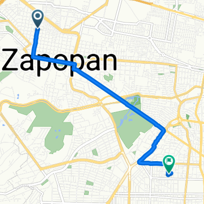
Anillo Periférico Norte Manuel Gómez Morín, Guadalajara a Calle Antonio García, Guadalajara
A cycling route starting in Zapopan, Jalisco, Mexico.
Overview
About this route
- 10 min
- Duration
- 2.9 km
- Distance
- 14 m
- Ascent
- 40 m
- Descent
- 17.2 km/h
- Avg. speed
- 1,549 m
- Max. altitude
Continue with Bikemap
Use, edit, or download this cycling route
You would like to ride Anillo Periférico Norte Manuel Gómez Morín, Guadalajara a Calle Antonio García, Guadalajara or customize it for your own trip? Here is what you can do with this Bikemap route:
Free features
- Save this route as favorite or in collections
- Copy & plan your own version of this route
- Sync your route with Garmin or Wahoo
Premium features
Free trial for 3 days, or one-time payment. More about Bikemap Premium.
- Navigate this route on iOS & Android
- Export a GPX / KML file of this route
- Create your custom printout (try it for free)
- Download this route for offline navigation
Discover more Premium features.
Get Bikemap PremiumFrom our community
Other popular routes starting in Zapopan
 Zc a Biblio Jal
- Distance
- 2.6 km
- Ascent
- 0 m
- Descent
- 5 m
- Location
- Zapopan, Jalisco, Mexico
 De Juan Antonio de la Fuente a Juan Antonio de la Fuente
- Distance
- 22.5 km
- Ascent
- 284 m
- Descent
- 259 m
- Location
- Zapopan, Jalisco, Mexico
 Paseo lento en Guadalajara
- Distance
- 7.4 km
- Ascent
- 44 m
- Descent
- 78 m
- Location
- Zapopan, Jalisco, Mexico
 ruta 1
- Distance
- 9.8 km
- Ascent
- 82 m
- Descent
- 89 m
- Location
- Zapopan, Jalisco, Mexico
 Jose Francisco Estrella
- Distance
- 11.6 km
- Ascent
- 113 m
- Descent
- 49 m
- Location
- Zapopan, Jalisco, Mexico
 Paseo lento en Guadalajara
- Distance
- 14.1 km
- Ascent
- 288 m
- Descent
- 286 m
- Location
- Zapopan, Jalisco, Mexico
 De Avenida Pablo Neruda 2460, Guadalajara a Calle Obsidiana 1109, Guadalajara
- Distance
- 7.1 km
- Ascent
- 91 m
- Descent
- 97 m
- Location
- Zapopan, Jalisco, Mexico
 Calle Puerto Bello 1556–1594, Guadalajara to Calle Rubén Darío 1505, Guadalajara
- Distance
- 4 km
- Ascent
- 22 m
- Descent
- 22 m
- Location
- Zapopan, Jalisco, Mexico
Open it in the app