
Albert-Haueisen-Ring 70, Ludwigshafen am Rhein to Wilhelm-Vorholz-Straße 41, Ludwigshafen am Rhein
A cycling route starting in Frankenthal, Rhineland-Palatinate, Germany.
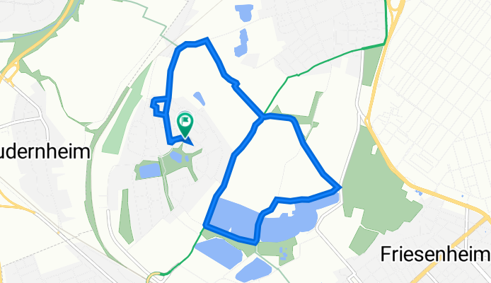
Overview
About this route
- 31 min
- Duration
- 9.1 km
- Distance
- 3 m
- Ascent
- 3 m
- Descent
- 17.7 km/h
- Avg. speed
- 96 m
- Max. altitude

Route quality
Waytypes & surfaces along the route
Waytypes
Track
5.3 km
(58 %)
Quiet road
3 km
(33 %)
Surfaces
Paved
5 km
(55 %)
Unpaved
4 km
(44 %)
Asphalt
4.4 km
(49 %)
Gravel
3.3 km
(36 %)
Continue with Bikemap
Use, edit, or download this cycling route
You would like to ride Albert-Haueisen-Ring 70, Ludwigshafen am Rhein to Wilhelm-Vorholz-Straße 41, Ludwigshafen am Rhein or customize it for your own trip? Here is what you can do with this Bikemap route:
Free features
- Save this route as favorite or in collections
- Copy & plan your own version of this route
- Sync your route with Garmin or Wahoo
Premium features
Free trial for 3 days, or one-time payment. More about Bikemap Premium.
- Navigate this route on iOS & Android
- Export a GPX / KML file of this route
- Create your custom printout (try it for free)
- Download this route for offline navigation
Discover more Premium features.
Get Bikemap PremiumFrom our community
Other popular routes starting in Frankenthal
 Wie im Urlaub - (über die Linde)
- Distance
- 85.4 km
- Ascent
- 617 m
- Descent
- 617 m
- Location
- Frankenthal, Rhineland-Palatinate, Germany
 Freinsheim
- Distance
- 41.2 km
- Ascent
- 51 m
- Descent
- 51 m
- Location
- Frankenthal, Rhineland-Palatinate, Germany
 ?dw?? nach ?dw??
- Distance
- 29.1 km
- Ascent
- 43 m
- Descent
- 41 m
- Location
- Frankenthal, Rhineland-Palatinate, Germany
 Ludwigshafen - Altrip
- Distance
- 43.2 km
- Ascent
- 135 m
- Descent
- 135 m
- Location
- Frankenthal, Rhineland-Palatinate, Germany
 Ä#!Û? nach Ä#!Û?
- Distance
- 21 km
- Ascent
- 569 m
- Descent
- 570 m
- Location
- Frankenthal, Rhineland-Palatinate, Germany
 FT, Ungeheuersee,FT
- Distance
- 49.5 km
- Ascent
- 477 m
- Descent
- 470 m
- Location
- Frankenthal, Rhineland-Palatinate, Germany
 Frankenthal Vorderpfalz
- Distance
- 45.7 km
- Ascent
- 55 m
- Descent
- 58 m
- Location
- Frankenthal, Rhineland-Palatinate, Germany
 Flomersheim - Maudacher Bruch
- Distance
- 21.4 km
- Ascent
- 20 m
- Descent
- 22 m
- Location
- Frankenthal, Rhineland-Palatinate, Germany
Open it in the app