

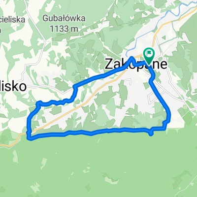
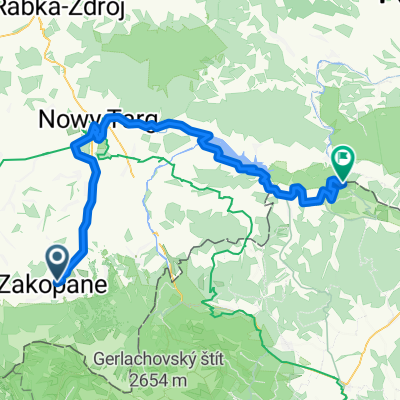
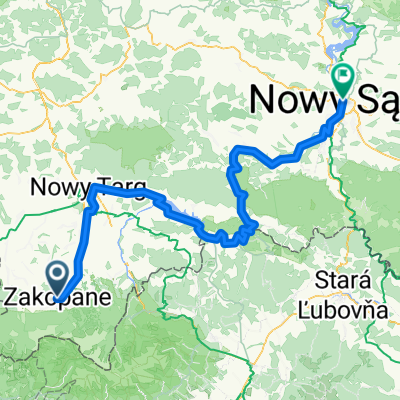
Velo Dunajec
A cycling route starting in Zakopane, Lesser Poland Voivodeship, Poland.
Overview
About this route
- -:--
- Duration
- 268.6 km
- Distance
- 1,631 m
- Ascent
- 2,262 m
- Descent
- ---
- Avg. speed
- 831 m
- Max. altitude

Route quality
Waytypes & surfaces along the route
Waytypes
Cycleway
102.1 km
(38 %)
Quiet road
59.1 km
(22 %)
Surfaces
Paved
239.1 km
(89 %)
Asphalt
225.7 km
(84 %)
Concrete
8.1 km
(3 %)
Route highlights
Points of interest along the route
Point of interest after 13 km
basen
Drinking water after 19 km
MC KFC
Bike service after 20.7 km
wiata
Bike service after 30.5 km
wiata
Bike service after 33.2 km
mor
Accommodation after 41.7 km
Camping Łęg nocleg
Bike service after 42 km
mor
Point of interest after 54.5 km
Zamek Czorsztyn
Point of interest after 55.3 km
Zamek w Niedzicy
Accommodation after 68.5 km
Czerwony Klasztor cemping
Accommodation after 133.3 km
Camping Dunajcowa 122, 33-300 Nowy Sącz
Continue with Bikemap
Use, edit, or download this cycling route
You would like to ride Velo Dunajec or customize it for your own trip? Here is what you can do with this Bikemap route:
Free features
- Save this route as favorite or in collections
- Copy & plan your own version of this route
- Split it into stages to create a multi-day tour
- Sync your route with Garmin or Wahoo
Premium features
Free trial for 3 days, or one-time payment. More about Bikemap Premium.
- Navigate this route on iOS & Android
- Export a GPX / KML file of this route
- Create your custom printout (try it for free)
- Download this route for offline navigation
Discover more Premium features.
Get Bikemap PremiumFrom our community
Other popular routes starting in Zakopane
 szlak 2
- Distance
- 12.7 km
- Ascent
- 366 m
- Descent
- 406 m
- Location
- Zakopane, Lesser Poland Voivodeship, Poland
 Day 2 Easier option
- Distance
- 15.5 km
- Ascent
- 661 m
- Descent
- 664 m
- Location
- Zakopane, Lesser Poland Voivodeship, Poland
 VeloDunajec (z objazdami brakujących odcinków)
- Distance
- 82.8 km
- Ascent
- 889 m
- Descent
- 1,282 m
- Location
- Zakopane, Lesser Poland Voivodeship, Poland
 D03v1ZaNoSa
- Distance
- 92.1 km
- Ascent
- 336 m
- Descent
- 900 m
- Location
- Zakopane, Lesser Poland Voivodeship, Poland
 Zakopane - Wierch Poroniec - Głodówka - Bukowina - Zakopane
- Distance
- 36.3 km
- Ascent
- 563 m
- Descent
- 563 m
- Location
- Zakopane, Lesser Poland Voivodeship, Poland
 13.07.20 Kopa Kondracka
- Distance
- 13.1 km
- Ascent
- 967 m
- Descent
- 962 m
- Location
- Zakopane, Lesser Poland Voivodeship, Poland
 VeloDunajec
- Distance
- 132 km
- Ascent
- 1,439 m
- Descent
- 1,977 m
- Location
- Zakopane, Lesser Poland Voivodeship, Poland
 49.222, 19.962 až 49.144, 19.903
- Distance
- 12.3 km
- Ascent
- 44 m
- Descent
- 441 m
- Location
- Zakopane, Lesser Poland Voivodeship, Poland
Open it in the app