

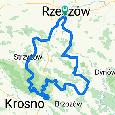
Roch - Chmielnik - Magdalenka - 42 Km
A cycling route starting in Rzeszów, Subcarpathian Voivodeship, Poland.
Overview
About this route
Przejazd: Rzeszów Olszynki, ul. Paderewskiego, Słocina, Św.Roch, Chmielnik, Magdalenka. Powrót Św.Roch, Słocina, Krzyżanowskiego.
- -:--
- Duration
- 42.4 km
- Distance
- 603 m
- Ascent
- 601 m
- Descent
- ---
- Avg. speed
- ---
- Max. altitude

Continue with Bikemap
Use, edit, or download this cycling route
You would like to ride Roch - Chmielnik - Magdalenka - 42 Km or customize it for your own trip? Here is what you can do with this Bikemap route:
Free features
- Save this route as favorite or in collections
- Copy & plan your own version of this route
- Sync your route with Garmin or Wahoo
Premium features
Free trial for 3 days, or one-time payment. More about Bikemap Premium.
- Navigate this route on iOS & Android
- Export a GPX / KML file of this route
- Create your custom printout (try it for free)
- Download this route for offline navigation
Discover more Premium features.
Get Bikemap PremiumFrom our community
Other popular routes starting in Rzeszów
 Kopce Jasienickie - szkic
- Distance
- 150.4 km
- Ascent
- 1,355 m
- Descent
- 1,358 m
- Location
- Rzeszów, Subcarpathian Voivodeship, Poland
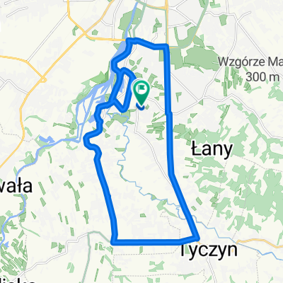
 Podjazd na Łany
- Distance
- 15.4 km
- Ascent
- 236 m
- Descent
- 233 m
- Location
- Rzeszów, Subcarpathian Voivodeship, Poland
 Niedzielna przejażdżka z rodziną i znajomymi
- Distance
- 59.1 km
- Ascent
- 120 m
- Descent
- 125 m
- Location
- Rzeszów, Subcarpathian Voivodeship, Poland
 Bieszczadzka majówka
- Distance
- 274.8 km
- Ascent
- 3,568 m
- Descent
- 3,208 m
- Location
- Rzeszów, Subcarpathian Voivodeship, Poland
 Rzeszów - Albigowa - Rzeszów
- Distance
- 63.2 km
- Ascent
- 417 m
- Descent
- 417 m
- Location
- Rzeszów, Subcarpathian Voivodeship, Poland
![[V] #006(z) - dłużej w dół rzeki](https://media.bikemap.net/routes/3142433/staticmaps/in_9f07e28a-df16-4c47-8c7c-951cb52e9d0b_400x400_bikemap-2021-3D-static.png) [V] #006(z) - dłużej w dół rzeki
[V] #006(z) - dłużej w dół rzeki- Distance
- 26.9 km
- Ascent
- 42 m
- Descent
- 42 m
- Location
- Rzeszów, Subcarpathian Voivodeship, Poland
 20+ trasa
- Distance
- 22.1 km
- Ascent
- 68 m
- Descent
- 69 m
- Location
- Rzeszów, Subcarpathian Voivodeship, Poland
 Rzeszów Hermanowa Rzeszów
- Distance
- 34 km
- Ascent
- 238 m
- Descent
- 238 m
- Location
- Rzeszów, Subcarpathian Voivodeship, Poland
Open it in the app