

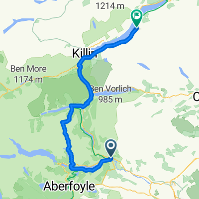
Aug 12 - aangepaste route
A cycling route starting in Callander, Scotland, United Kingdom.
Overview
About this route
- -:--
- Duration
- 66.2 km
- Distance
- 975 m
- Ascent
- 976 m
- Descent
- ---
- Avg. speed
- 214 m
- Max. altitude

Route quality
Waytypes & surfaces along the route
Waytypes
Road
39 km
(59 %)
Track
8.6 km
(13 %)
Surfaces
Paved
34.4 km
(52 %)
Unpaved
5.3 km
(8 %)
Asphalt
34.4 km
(52 %)
Gravel
5.3 km
(8 %)
Undefined
26.5 km
(40 %)
Route highlights
Points of interest along the route
Point of interest after 33.1 km
Cafe na 50km
Drinking water after 35 km
The clansman (bar/resto) geen openingstijden bekend
Continue with Bikemap
Use, edit, or download this cycling route
You would like to ride Aug 12 - aangepaste route or customize it for your own trip? Here is what you can do with this Bikemap route:
Free features
- Save this route as favorite or in collections
- Copy & plan your own version of this route
- Sync your route with Garmin or Wahoo
Premium features
Free trial for 3 days, or one-time payment. More about Bikemap Premium.
- Navigate this route on iOS & Android
- Export a GPX / KML file of this route
- Create your custom printout (try it for free)
- Download this route for offline navigation
Discover more Premium features.
Get Bikemap PremiumFrom our community
Other popular routes starting in Callander
 Route 2
- Distance
- 7.2 km
- Ascent
- 25 m
- Descent
- 82 m
- Location
- Callander, Scotland, United Kingdom
 Jogle Day 5
- Distance
- 114.3 km
- Ascent
- 789 m
- Descent
- 713 m
- Location
- Callander, Scotland, United Kingdom
 Day 2 / Scotland - 120km / 1700hm
- Distance
- 116.6 km
- Ascent
- 1,835 m
- Descent
- 1,834 m
- Location
- Callander, Scotland, United Kingdom
 Aug 12 - aangepaste route
- Distance
- 66.2 km
- Ascent
- 975 m
- Descent
- 976 m
- Location
- Callander, Scotland, United Kingdom
 Tag 50: Trossachs National Park 2
- Distance
- 50.5 km
- Ascent
- 502 m
- Descent
- 549 m
- Location
- Callander, Scotland, United Kingdom
 God awful route
- Distance
- 89.5 km
- Ascent
- 1,660 m
- Descent
- 1,607 m
- Location
- Callander, Scotland, United Kingdom
 09 - Callander to Alyth
- Distance
- 101.2 km
- Ascent
- 457 m
- Descent
- 419 m
- Location
- Callander, Scotland, United Kingdom
 Callander to Loch Tay
- Distance
- 65.6 km
- Ascent
- 1,157 m
- Descent
- 1,058 m
- Location
- Callander, Scotland, United Kingdom
Open it in the app