

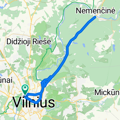
Recovered Route
A cycling route starting in Šeškinė, Vilnius County, Lithuania.
Overview
About this route
- 2 h 17 min
- Duration
- 20.8 km
- Distance
- 295 m
- Ascent
- 252 m
- Descent
- 9.1 km/h
- Avg. speed
- 175 m
- Max. altitude

Route photos


Route quality
Waytypes & surfaces along the route
Waytypes
Path
10.6 km
(51 %)
Pedestrian area
4.4 km
(21 %)
Surfaces
Paved
16.5 km
(79 %)
Unpaved
1.6 km
(8 %)
Asphalt
10 km
(48 %)
Paving stones
3.3 km
(16 %)
Continue with Bikemap
Use, edit, or download this cycling route
You would like to ride Recovered Route or customize it for your own trip? Here is what you can do with this Bikemap route:
Free features
- Save this route as favorite or in collections
- Copy & plan your own version of this route
- Sync your route with Garmin or Wahoo
Premium features
Free trial for 3 days, or one-time payment. More about Bikemap Premium.
- Navigate this route on iOS & Android
- Export a GPX / KML file of this route
- Create your custom printout (try it for free)
- Download this route for offline navigation
Discover more Premium features.
Get Bikemap PremiumFrom our community
Other popular routes starting in Šeškinė
 Maišiagalos gatvė 32, Vilnius to Kalvarijų gatvė 178, Vilnius
- Distance
- 8.3 km
- Ascent
- 63 m
- Descent
- 63 m
- Location
- Šeškinė, Vilnius County, Lithuania
 Route from Šeškinės kalvos, Vilnius
- Distance
- 52.9 km
- Ascent
- 225 m
- Descent
- 228 m
- Location
- Šeškinė, Vilnius County, Lithuania
 Jurgio Lebedžio g. 9, Vilnius to Jurgio Lebedžio g. 9, Vilnius
- Distance
- 15 km
- Ascent
- 129 m
- Descent
- 222 m
- Location
- Šeškinė, Vilnius County, Lithuania
 Route in Vilnius
- Distance
- 51.8 km
- Ascent
- 330 m
- Descent
- 328 m
- Location
- Šeškinė, Vilnius County, Lithuania
 Recovered Route
- Distance
- 20.8 km
- Ascent
- 295 m
- Descent
- 252 m
- Location
- Šeškinė, Vilnius County, Lithuania
 Jurgio Lebedžio g. 9, Vilnius to Jurgio Lebedžio g. 9, Vilnius
- Distance
- 20.2 km
- Ascent
- 187 m
- Descent
- 183 m
- Location
- Šeškinė, Vilnius County, Lithuania
 Ozo gatvė 30B, Vilnius to Ozo gatvė 30B, Vilnius
- Distance
- 11.4 km
- Ascent
- 127 m
- Descent
- 124 m
- Location
- Šeškinė, Vilnius County, Lithuania
 Vilnius-TRAKAI
- Distance
- 30.2 km
- Ascent
- 217 m
- Descent
- 230 m
- Location
- Šeškinė, Vilnius County, Lithuania
Open it in the app