

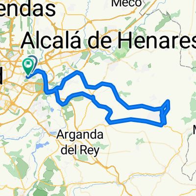
Coslada - Paracuellos del Jarama - Dehesa de Cobeña - Daganzo de Arriba - Coslada
A cycling route starting in Coslada, Madrid, Spain.
Overview
About this route
Almost 60 kilometers on the road. To Paracuellos via its gentler side, then on to Cobeña, stopping at the Dehesa de Cobeña. We return via Daganzo and the Torrejón Aerodrome.
- -:--
- Duration
- 57.2 km
- Distance
- 340 m
- Ascent
- 345 m
- Descent
- ---
- Avg. speed
- ---
- Max. altitude

Route highlights
Points of interest along the route
Point of interest after 17.3 km
En vez de entrar a Paracuellos, lo vamos bordeando por los caminos exteriores.
Point of interest after 21.1 km
En la rotonda de acceso a Paracuellos, tomamos la pista que más adelante cruzará la M50.
Point of interest after 23.6 km
Una vez llegamos a la nave con techo verde, seguimos por el "sembrado" que bordea la finca.
Point of interest after 25 km
Bifurcación. A la izquierda.
Point of interest after 27.2 km
Una vez entramos a Cobeña, ascendemos por nuestra derecha en dirección a la M118.
Point of interest after 28.3 km
M-118. Ascendemos por nuestra izquierda
Point of interest after 28.9 km
Semáforo. Giramos en la primera calle que se abre a nuestra derecha.
Point of interest after 29.2 km
La carretera torna en carril bici. Si seguimos de frente, daremos con una laguna con patos.
Point of interest after 30.4 km
Cruce de caminos. Tomamos el camino de nuestra izquierda.
Point of interest after 31.4 km
Cementerio de Algete. Una pista bordea el camposanto. La tomamos y seguimos de frente hasta Daganzo.
Point of interest after 36.7 km
Una vez en Daganzo, buscamos el Polígono y la pista que desciende hacia el Aeródromo de Torrejón.
Continue with Bikemap
Use, edit, or download this cycling route
You would like to ride Coslada - Paracuellos del Jarama - Dehesa de Cobeña - Daganzo de Arriba - Coslada or customize it for your own trip? Here is what you can do with this Bikemap route:
Free features
- Save this route as favorite or in collections
- Copy & plan your own version of this route
- Sync your route with Garmin or Wahoo
Premium features
Free trial for 3 days, or one-time payment. More about Bikemap Premium.
- Navigate this route on iOS & Android
- Export a GPX / KML file of this route
- Create your custom printout (try it for free)
- Download this route for offline navigation
Discover more Premium features.
Get Bikemap PremiumFrom our community
Other popular routes starting in Coslada
 39 bis 20251019 Nuevo Baztán 90 km
- Distance
- 89.7 km
- Ascent
- 6,536 m
- Descent
- 6,546 m
- Location
- Coslada, Madrid, Spain
 Coslada - Paracuellos del Jarama - Dehesa de Cobeña - Daganzo de Arriba - Coslada
- Distance
- 57.2 km
- Ascent
- 340 m
- Descent
- 345 m
- Location
- Coslada, Madrid, Spain
 Coslada - Villalbilla
- Distance
- 30.6 km
- Ascent
- 219 m
- Descent
- 114 m
- Location
- Coslada, Madrid, Spain
 Coslada - Torres de la Alameda - Valverde de Alcalá - Villalbilla - Los Hueros - Coslada
- Distance
- 67.2 km
- Ascent
- 406 m
- Descent
- 408 m
- Location
- Coslada, Madrid, Spain
 Coslada - Ajalvir - Paracuellos - Coslada
- Distance
- 47.8 km
- Ascent
- 270 m
- Descent
- 274 m
- Location
- Coslada, Madrid, Spain
 Coslada - El Goloso - Coslada
- Distance
- 60.7 km
- Ascent
- 286 m
- Descent
- 292 m
- Location
- Coslada, Madrid, Spain
 Propuesta Red MTB 2010 Corredor del Henares
- Distance
- 49.7 km
- Ascent
- 296 m
- Descent
- 316 m
- Location
- Coslada, Madrid, Spain
 33 evitando cortes 20250907 Meco 108 km
- Distance
- 107.9 km
- Ascent
- 3,329 m
- Descent
- 3,339 m
- Location
- Coslada, Madrid, Spain
Open it in the app