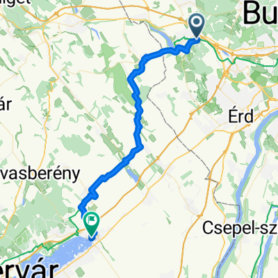
Bia-Sóskút-Érd-MTB
A cycling route starting in Biatorbágy, Pest County, Hungary.
Overview
About this route
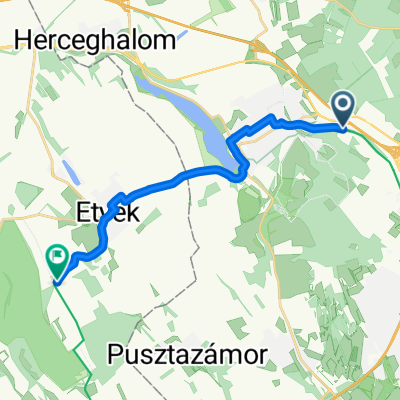
Hilly track, best suited for MTBs. Avoid in rainy weather.
- -:--
- Duration
- 28.9 km
- Distance
- 567 m
- Ascent
- 567 m
- Descent
- ---
- Avg. speed
- ---
- Max. altitude
Route quality
Waytypes & surfaces along the route
Waytypes
Track
12.7 km
(44 %)
Quiet road
8.3 km
(29 %)
Surfaces
Paved
8.2 km
(28 %)
Unpaved
16.3 km
(56 %)
Gravel
8 km
(28 %)
Ground
7.4 km
(26 %)
Continue with Bikemap
Use, edit, or download this cycling route
You would like to ride Bia-Sóskút-Érd-MTB or customize it for your own trip? Here is what you can do with this Bikemap route:
Free features
- Save this route as favorite or in collections
- Copy & plan your own version of this route
- Sync your route with Garmin or Wahoo
Premium features
Free trial for 3 days, or one-time payment. More about Bikemap Premium.
- Navigate this route on iOS & Android
- Export a GPX / KML file of this route
- Create your custom printout (try it for free)
- Download this route for offline navigation
Discover more Premium features.
Get Bikemap PremiumFrom our community
Other popular routes starting in Biatorbágy
- Biatorbágyi tekergés
- Distance
- 25.5 km
- Ascent
- 454 m
- Descent
- 454 m
- Location
- Biatorbágy, Pest County, Hungary
- Cycling from Biatorbágy to Velence
- Distance
- 76.2 km
- Ascent
- 652 m
- Descent
- 708 m
- Location
- Biatorbágy, Pest County, Hungary
- Etyeki kör - From Biatorbágy
- Distance
- 51.2 km
- Ascent
- 410 m
- Descent
- 410 m
- Location
- Biatorbágy, Pest County, Hungary
- 60km ride
- Distance
- 58.2 km
- Ascent
- 456 m
- Descent
- 456 m
- Location
- Biatorbágy, Pest County, Hungary
- Etyeki útvonal 2 42 km
- Distance
- 42.2 km
- Ascent
- 175 m
- Descent
- 168 m
- Location
- Biatorbágy, Pest County, Hungary
- Budapest - Zürich
- Distance
- 1,067.1 km
- Ascent
- 967 m
- Descent
- 726 m
- Location
- Biatorbágy, Pest County, Hungary
- Bia-Sóskút-Érd-MTB
- Distance
- 28.9 km
- Ascent
- 567 m
- Descent
- 567 m
- Location
- Biatorbágy, Pest County, Hungary
- Csajos edzés Tatára
- Distance
- 58.5 km
- Ascent
- 380 m
- Descent
- 429 m
- Location
- Biatorbágy, Pest County, Hungary
Open it in the app