

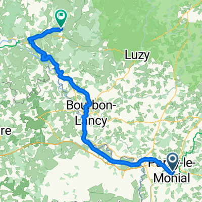
Avenue Jean-Paul II 8, Paray-le-Monial nach Nevers Le Mouesse ANPE
A cycling route starting in Paray-le-Monial, Bourgogne-Franche-Comté, France.
Overview
About this route
- 7 h 46 min
- Duration
- 130.1 km
- Distance
- 386 m
- Ascent
- 446 m
- Descent
- 16.7 km/h
- Avg. speed
- 263 m
- Avg. speed

Route quality
Waytypes & surfaces along the route
Waytypes
Path
43.2 km
(33 %)
Quiet road
35.1 km
(27 %)
Surfaces
Paved
92.3 km
(71 %)
Unpaved
1.5 km
(1 %)
Asphalt
86.2 km
(66 %)
Paved (undefined)
5.9 km
(5 %)
Continue with Bikemap
Use, edit, or download this cycling route
You would like to ride Avenue Jean-Paul II 8, Paray-le-Monial nach Nevers Le Mouesse ANPE or customize it for your own trip? Here is what you can do with this Bikemap route:
Free features
- Save this route as favorite or in collections
- Copy & plan your own version of this route
- Sync your route with Garmin or Wahoo
Premium features
Free trial for 3 days, or one-time payment. More about Bikemap Premium.
- Navigate this route on iOS & Android
- Export a GPX / KML file of this route
- Create your custom printout (try it for free)
- Download this route for offline navigation
Discover more Premium features.
Get Bikemap PremiumFrom our community
Other popular routes starting in Paray-le-Monial
 L4 Teil 1: Paray-le-Monial - Montceau-les-Mines; 37,2km 110hm
- Distance
- 37.2 km
- Ascent
- 156 m
- Descent
- 105 m
- Location
- Paray-le-Monial, Bourgogne-Franche-Comté, France
 2014_E7b_Paray-le- monial_Cluny
- Distance
- 54.3 km
- Ascent
- 624 m
- Descent
- 626 m
- Location
- Paray-le-Monial, Bourgogne-Franche-Comté, France
 Paray-le-Monial nach Digoin und zurück
- Distance
- 13.3 km
- Ascent
- 15 m
- Descent
- 30 m
- Location
- Paray-le-Monial, Bourgogne-Franche-Comté, France
 massif east 1
- Distance
- 473.1 km
- Ascent
- 2,609 m
- Descent
- 2,698 m
- Location
- Paray-le-Monial, Bourgogne-Franche-Comté, France
 Etape 6: bourgogne bis
- Distance
- 47.8 km
- Ascent
- 339 m
- Descent
- 292 m
- Location
- Paray-le-Monial, Bourgogne-Franche-Comté, France
 Etape 6 Paray le Monial - Cercy-La-Tour
- Distance
- 98.3 km
- Ascent
- 172 m
- Descent
- 199 m
- Location
- Paray-le-Monial, Bourgogne-Franche-Comté, France
 Paray-le-Monial : circuit n°11 - Vues sur la vallée de l'Arconce, Nochize
- Distance
- 31.5 km
- Ascent
- 195 m
- Descent
- 195 m
- Location
- Paray-le-Monial, Bourgogne-Franche-Comté, France
 L3+4 nord sehr lang: Paray-le-Monial - Macon; 376km 660hm
- Distance
- 384.7 km
- Ascent
- 1,525 m
- Descent
- 1,575 m
- Location
- Paray-le-Monial, Bourgogne-Franche-Comté, France
Open it in the app