

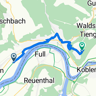
Itinéraire vers Hauptstraße 18, Hohentengen am Hochrhein
A cycling route starting in Leibstadt, Canton of Aargau, Switzerland.
Overview
About this route
- 2 h 25 min
- Duration
- 28.8 km
- Distance
- 244 m
- Ascent
- 185 m
- Descent
- 11.9 km/h
- Avg. speed
- 375 m
- Max. altitude

Route quality
Waytypes & surfaces along the route
Waytypes
Quiet road
12.1 km
(42 %)
Road
4.3 km
(15 %)
Surfaces
Paved
24.5 km
(85 %)
Unpaved
2.3 km
(8 %)
Asphalt
24.5 km
(85 %)
Gravel
2.3 km
(8 %)
Undefined
2 km
(7 %)
Continue with Bikemap
Use, edit, or download this cycling route
You would like to ride Itinéraire vers Hauptstraße 18, Hohentengen am Hochrhein or customize it for your own trip? Here is what you can do with this Bikemap route:
Free features
- Save this route as favorite or in collections
- Copy & plan your own version of this route
- Sync your route with Garmin or Wahoo
Premium features
Free trial for 3 days, or one-time payment. More about Bikemap Premium.
- Navigate this route on iOS & Android
- Export a GPX / KML file of this route
- Create your custom printout (try it for free)
- Download this route for offline navigation
Discover more Premium features.
Get Bikemap PremiumFrom our community
Other popular routes starting in Leibstadt
 ALDI - Aarberg
- Distance
- 6 km
- Ascent
- 137 m
- Descent
- 20 m
- Location
- Leibstadt, Canton of Aargau, Switzerland
 Hettenschwil - Oedenholz
- Distance
- 2.9 km
- Ascent
- 156 m
- Descent
- 5 m
- Location
- Leibstadt, Canton of Aargau, Switzerland
 SVD - KKL - Albbruck - SVD
- Distance
- 16.9 km
- Ascent
- 144 m
- Descent
- 146 m
- Location
- Leibstadt, Canton of Aargau, Switzerland
 Mandacher Höhe und entlang des Rheins
- Distance
- 44.8 km
- Ascent
- 475 m
- Descent
- 475 m
- Location
- Leibstadt, Canton of Aargau, Switzerland
 Rheinradweg Velolager Route 4
- Distance
- 41.5 km
- Ascent
- 127 m
- Descent
- 182 m
- Location
- Leibstadt, Canton of Aargau, Switzerland
 Itinéraire vers Hauptstraße 18, Hohentengen am Hochrhein
- Distance
- 28.8 km
- Ascent
- 244 m
- Descent
- 185 m
- Location
- Leibstadt, Canton of Aargau, Switzerland
 Runde mit Matze
- Distance
- 46.4 km
- Ascent
- 401 m
- Descent
- 400 m
- Location
- Leibstadt, Canton of Aargau, Switzerland
 Bergauf - bergab. Hügelige Runde mit I
- Distance
- 46.6 km
- Ascent
- 773 m
- Descent
- 773 m
- Location
- Leibstadt, Canton of Aargau, Switzerland
Open it in the app