

Oregon Biking Trip
Wednesday - Astoria to Nehalem State Park
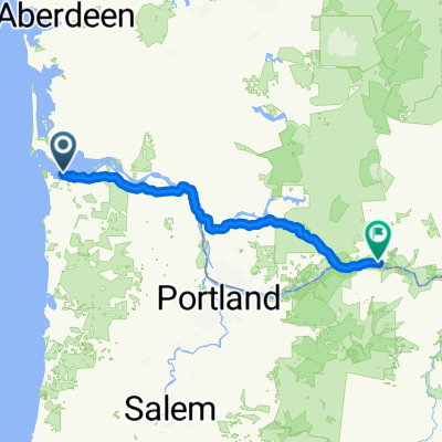
A cycling route starting in Astoria, Oregon, United States.
Overview
About this route
Wednesday route
- 4 h 5 min
- Duration
- 72.7 km
- Distance
- 1,274 m
- Ascent
- 1,265 m
- Descent
- 17.8 km/h
- Avg. speed
- 188 m
- Max. altitude
Part of
Oregon Biking Trip
5 stages
Route quality
Waytypes & surfaces along the route
Waytypes
Cycleway
27.6 km
(38 %)
Road
22.5 km
(31 %)
Surfaces
Paved
22.5 km
(31 %)
Asphalt
20.4 km
(28 %)
Paved (undefined)
1.5 km
(2 %)
Continue with Bikemap
Use, edit, or download this cycling route
You would like to ride Wednesday - Astoria to Nehalem State Park or customize it for your own trip? Here is what you can do with this Bikemap route:
Free features
- Save this route as favorite or in collections
- Copy & plan your own version of this route
- Sync your route with Garmin or Wahoo
Premium features
Free trial for 3 days, or one-time payment. More about Bikemap Premium.
- Navigate this route on iOS & Android
- Export a GPX / KML file of this route
- Create your custom printout (try it for free)
- Download this route for offline navigation
Discover more Premium features.
Get Bikemap PremiumFrom our community
Other popular routes starting in Astoria
 Trans America
- Distance
- 6,346.5 km
- Ascent
- 6,325 m
- Descent
- 6,310 m
- Location
- Astoria, Oregon, United States
 # 2. Astoria, Wa to Portland to White Salmon, WA
- Distance
- 254.1 km
- Ascent
- 2,394 m
- Descent
- 2,213 m
- Location
- Astoria, Oregon, United States
 Cycle For Life 2020
- Distance
- 2,869.1 km
- Ascent
- 7,227 m
- Descent
- 5,433 m
- Location
- Astoria, Oregon, United States
 Astoria to Tilamook via 101
- Distance
- 100.1 km
- Ascent
- 502 m
- Descent
- 501 m
- Location
- Astoria, Oregon, United States
 Skyline Avenue 97, Astoria to Alameda Avenue 225, Astoria
- Distance
- 19.8 km
- Ascent
- 133 m
- Descent
- 226 m
- Location
- Astoria, Oregon, United States
 astoria, or. to pender ave.
- Distance
- 5,402.9 km
- Ascent
- 22,270 m
- Descent
- 22,261 m
- Location
- Astoria, Oregon, United States
 Tier 1
- Distance
- 4,822.7 km
- Ascent
- 4,723 m
- Descent
- 4,574 m
- Location
- Astoria, Oregon, United States
 Cross Country Route for 2016
- Distance
- 6,067.5 km
- Ascent
- 7,734 m
- Descent
- 7,729 m
- Location
- Astoria, Oregon, United States
Open it in the app