

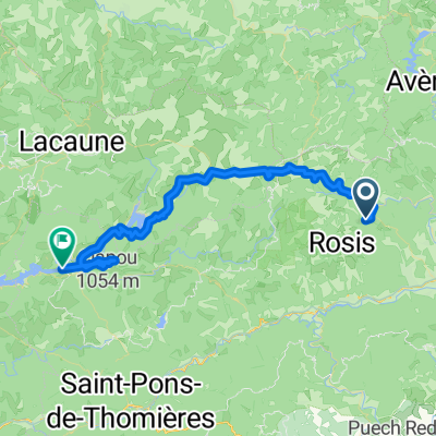
De Route de Nébuzon 70, Rosis à Route de Nébuzon 4, Rosis
A cycling route starting in Lamalou-les-Bains, Occitanie, France.
Overview
About this route
- 2 h 21 min
- Duration
- 19.5 km
- Distance
- 345 m
- Ascent
- 337 m
- Descent
- 8.3 km/h
- Avg. speed
- 469 m
- Max. altitude

Route quality
Waytypes & surfaces along the route
Waytypes
Quiet road
6.6 km
(34 %)
Track
4.5 km
(23 %)
Surfaces
Paved
2.9 km
(15 %)
Unpaved
4.1 km
(21 %)
Asphalt
2.7 km
(14 %)
Gravel
2.3 km
(12 %)
Continue with Bikemap
Use, edit, or download this cycling route
You would like to ride De Route de Nébuzon 70, Rosis à Route de Nébuzon 4, Rosis or customize it for your own trip? Here is what you can do with this Bikemap route:
Free features
- Save this route as favorite or in collections
- Copy & plan your own version of this route
- Sync your route with Garmin or Wahoo
Premium features
Free trial for 3 days, or one-time payment. More about Bikemap Premium.
- Navigate this route on iOS & Android
- Export a GPX / KML file of this route
- Create your custom printout (try it for free)
- Download this route for offline navigation
Discover more Premium features.
Get Bikemap PremiumFrom our community
Other popular routes starting in Lamalou-les-Bains
 004 Lamalou-les-Bains - Mazamet
- Distance
- 69.2 km
- Ascent
- 990 m
- Descent
- 916 m
- Location
- Lamalou-les-Bains, Occitanie, France
 R-20180905-France-17
- Distance
- 55 km
- Ascent
- 930 m
- Descent
- 614 m
- Location
- Lamalou-les-Bains, Occitanie, France
 L'Horte (FR)_105 km
- Distance
- 105.3 km
- Ascent
- 1,379 m
- Descent
- 1,399 m
- Location
- Lamalou-les-Bains, Occitanie, France
 dag 5
dag 5- Distance
- 48.1 km
- Ascent
- 729 m
- Descent
- 997 m
- Location
- Lamalou-les-Bains, Occitanie, France
 L'Horte (FR)_30 km
- Distance
- 30 km
- Ascent
- 773 m
- Descent
- 790 m
- Location
- Lamalou-les-Bains, Occitanie, France
 L'Horte (FR)_90 km
- Distance
- 88.6 km
- Ascent
- 1,686 m
- Descent
- 1,684 m
- Location
- Lamalou-les-Bains, Occitanie, France
 De Route du Panissel 708, Rosis à Boulevard de Verdun 12 bis, Béziers
- Distance
- 47.1 km
- Ascent
- 656 m
- Descent
- 1,036 m
- Location
- Lamalou-les-Bains, Occitanie, France
 L'Horte (FR)_55 km Col de L'Espinouse
- Distance
- 56.7 km
- Ascent
- 1,276 m
- Descent
- 1,318 m
- Location
- Lamalou-les-Bains, Occitanie, France
Open it in the app