

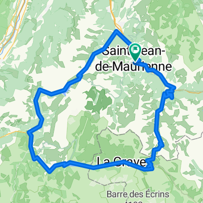
Col de la Madeleine via Col du Chaussy
A cycling route starting in Saint-Jean-de-Maurienne, Auvergne-Rhône-Alpes, France.
Overview
About this route
<img src="http://farm8.staticflickr.com/7154/6420188307_0ea9631be3_m.jpg" alt="Lacets de Montvernier" width="180" height="240" />
- -:--
- Duration
- 58.9 km
- Distance
- 1,952 m
- Ascent
- 1,952 m
- Descent
- ---
- Avg. speed
- ---
- Max. altitude

Route quality
Waytypes & surfaces along the route
Waytypes
Road
16.5 km
(28 %)
Quiet road
8.2 km
(14 %)
Surfaces
Paved
35.9 km
(61 %)
Unpaved
7.1 km
(12 %)
Asphalt
35.9 km
(61 %)
Gravel
7.1 km
(12 %)
Undefined
15.9 km
(27 %)
Route highlights
Points of interest along the route
Point of interest after 1.7 km
Lacets de Montvernier
Point of interest after 4.5 km
Cliff photo location :) After church turn right and ride through the fields
Point of interest after 16.1 km
Col du Chaussy
Point of interest after 25.3 km
La Grolle - 1800 metres - cross into next valley
Point of interest after 32.8 km
Col de la Madeleine
Continue with Bikemap
Use, edit, or download this cycling route
You would like to ride Col de la Madeleine via Col du Chaussy or customize it for your own trip? Here is what you can do with this Bikemap route:
Free features
- Save this route as favorite or in collections
- Copy & plan your own version of this route
- Sync your route with Garmin or Wahoo
Premium features
Free trial for 3 days, or one-time payment. More about Bikemap Premium.
- Navigate this route on iOS & Android
- Export a GPX / KML file of this route
- Create your custom printout (try it for free)
- Download this route for offline navigation
Discover more Premium features.
Get Bikemap PremiumFrom our community
Other popular routes starting in Saint-Jean-de-Maurienne
 Maurienne - J3 Bis
- Distance
- 165.7 km
- Ascent
- 3,339 m
- Descent
- 3,340 m
- Location
- Saint-Jean-de-Maurienne, Auvergne-Rhône-Alpes, France
 Col de la Croix de Fer- Col du Glandon
- Distance
- 62.3 km
- Ascent
- 1,665 m
- Descent
- 1,665 m
- Location
- Saint-Jean-de-Maurienne, Auvergne-Rhône-Alpes, France
 Subidas a los Cols de Glandon-Croix de Fer y de la Madeleine
- Distance
- 132.6 km
- Ascent
- 3,278 m
- Descent
- 3,285 m
- Location
- Saint-Jean-de-Maurienne, Auvergne-Rhône-Alpes, France
 Etape reine CFJ Tour 2021
- Distance
- 71.7 km
- Ascent
- 1,981 m
- Descent
- 1,960 m
- Location
- Saint-Jean-de-Maurienne, Auvergne-Rhône-Alpes, France
 020 - 2014
- Distance
- 71.8 km
- Ascent
- 1,404 m
- Descent
- 178 m
- Location
- Saint-Jean-de-Maurienne, Auvergne-Rhône-Alpes, France
 chaussy
- Distance
- 67.8 km
- Ascent
- 2,279 m
- Descent
- 2,290 m
- Location
- Saint-Jean-de-Maurienne, Auvergne-Rhône-Alpes, France
 Maurienne - J4
- Distance
- 76.9 km
- Ascent
- 2,005 m
- Descent
- 2,005 m
- Location
- Saint-Jean-de-Maurienne, Auvergne-Rhône-Alpes, France
 Etape intermédiaire CFJ Tour 2021 Montvernier
- Distance
- 47.5 km
- Ascent
- 1,159 m
- Descent
- 1,227 m
- Location
- Saint-Jean-de-Maurienne, Auvergne-Rhône-Alpes, France
Open it in the app