
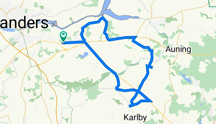
Højvangen 15, Randers SØ to Højvangen 15, Randers SØ
A cycling route starting in Assentoft, Central Jutland, Denmark.
Overview
About this route
- 2 h 14 min
- Duration
- 47.6 km
- Distance
- 324 m
- Ascent
- 327 m
- Descent
- 21.2 km/h
- Avg. speed
- 53 m
- Max. altitude

Route photos


Route quality
Waytypes & surfaces along the route
Waytypes
Road
33.8 km
(71 %)
Quiet road
2.4 km
(5 %)
Undefined
11.4 km
(24 %)
Surfaces
Paved
47.1 km
(99 %)
Asphalt
47.1 km
(99 %)
Undefined
0.5 km
(1 %)
Continue with Bikemap
Use, edit, or download this cycling route
You would like to ride Højvangen 15, Randers SØ to Højvangen 15, Randers SØ or customize it for your own trip? Here is what you can do with this Bikemap route:
Free features
- Save this route as favorite or in collections
- Copy & plan your own version of this route
- Sync your route with Garmin or Wahoo
Premium features
Free trial for 3 days, or one-time payment. More about Bikemap Premium.
- Navigate this route on iOS & Android
- Export a GPX / KML file of this route
- Create your custom printout (try it for free)
- Download this route for offline navigation
Discover more Premium features.
Get Bikemap PremiumFrom our community
Other popular routes starting in Assentoft
 Højvangen 15, Randers SØ to Højvangen 15, Randers SØ
- Distance
- 47.6 km
- Ascent
- 324 m
- Descent
- 327 m
- Location
- Assentoft, Central Jutland, Denmark
 Nishiki stor rute af 20 km - 2013
- Distance
- 20.2 km
- Ascent
- 150 m
- Descent
- 150 m
- Location
- Assentoft, Central Jutland, Denmark
 Højvangen 17, Randers SØ to Nedre Vej 106, Randers NØ
- Distance
- 19 km
- Ascent
- 58 m
- Descent
- 104 m
- Location
- Assentoft, Central Jutland, Denmark
 Højvangen 17, Randers SØ to Højvangen 17, Randers SØ
- Distance
- 15.2 km
- Ascent
- 97 m
- Descent
- 95 m
- Location
- Assentoft, Central Jutland, Denmark
 Dag 5 Randers Regnskov
- Distance
- 16.5 km
- Ascent
- 70 m
- Descent
- 73 m
- Location
- Assentoft, Central Jutland, Denmark
 Højvangen 15, Randers SØ to Højvangen 17, Randers SØ
- Distance
- 32.9 km
- Ascent
- 229 m
- Descent
- 230 m
- Location
- Assentoft, Central Jutland, Denmark
 Stånum (Randers Kom) to Klokbakken 16, Hjortshøj
- Distance
- 26.8 km
- Ascent
- 168 m
- Descent
- 145 m
- Location
- Assentoft, Central Jutland, Denmark
 62 km rute til sødring mtb
- Distance
- 61.2 km
- Ascent
- 282 m
- Descent
- 280 m
- Location
- Assentoft, Central Jutland, Denmark
Open it in the app