

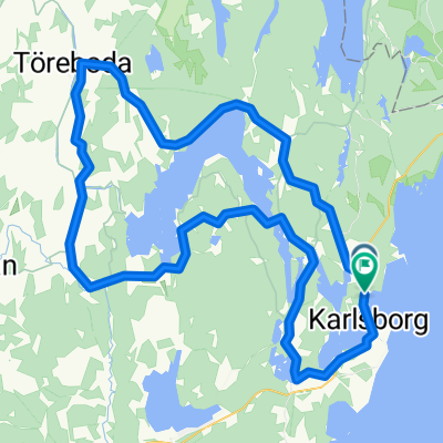
Strömsnäs camping 1, Forsvik nach Stockshammar 318, Askersund
A cycling route starting in Karlsborg, Västra Götaland County, Sweden.
Overview
About this route
- 5 h 33 min
- Duration
- 66.4 km
- Distance
- 2,174 m
- Ascent
- 2,186 m
- Descent
- 12 km/h
- Avg. speed
- 211 m
- Max. altitude

Route quality
Waytypes & surfaces along the route
Waytypes
Quiet road
29.2 km
(44 %)
Road
19.9 km
(30 %)
Surfaces
Paved
38.7 km
(58 %)
Unpaved
26.1 km
(39 %)
Asphalt
38.7 km
(58 %)
Unpaved (undefined)
12.5 km
(19 %)
Continue with Bikemap
Use, edit, or download this cycling route
You would like to ride Strömsnäs camping 1, Forsvik nach Stockshammar 318, Askersund or customize it for your own trip? Here is what you can do with this Bikemap route:
Free features
- Save this route as favorite or in collections
- Copy & plan your own version of this route
- Sync your route with Garmin or Wahoo
Premium features
Free trial for 3 days, or one-time payment. More about Bikemap Premium.
- Navigate this route on iOS & Android
- Export a GPX / KML file of this route
- Create your custom printout (try it for free)
- Download this route for offline navigation
Discover more Premium features.
Get Bikemap PremiumFrom our community
Other popular routes starting in Karlsborg
 Hagenvägen, Forsvik nach Östra Vallgatan, Karlsborg
- Distance
- 14.1 km
- Ascent
- 65 m
- Descent
- 59 m
- Location
- Karlsborg, Västra Götaland County, Sweden
 100k Giro
- Distance
- 100.8 km
- Ascent
- 676 m
- Descent
- 677 m
- Location
- Karlsborg, Västra Götaland County, Sweden
 EMU Sweden 2020 Etappe 5
- Distance
- 61 km
- Ascent
- 270 m
- Descent
- 289 m
- Location
- Karlsborg, Västra Götaland County, Sweden
 22 tappa Bergamo-Nordkapp
- Distance
- 109.1 km
- Ascent
- 517 m
- Descent
- 346 m
- Location
- Karlsborg, Västra Götaland County, Sweden
 Västgötaleden Karlsborg ToR
- Distance
- 274.2 km
- Ascent
- 584 m
- Descent
- 585 m
- Location
- Karlsborg, Västra Götaland County, Sweden
 Route in Karlsborg
- Distance
- 64 km
- Ascent
- 471 m
- Descent
- 473 m
- Location
- Karlsborg, Västra Götaland County, Sweden
 Forsvik - Borensberg 15 MAI 13
- Distance
- 108.4 km
- Ascent
- 373 m
- Descent
- 402 m
- Location
- Karlsborg, Västra Götaland County, Sweden
 Dag 12: Undenas - Latorp
- Distance
- 68.4 km
- Ascent
- 587 m
- Descent
- 681 m
- Location
- Karlsborg, Västra Götaland County, Sweden
Open it in the app