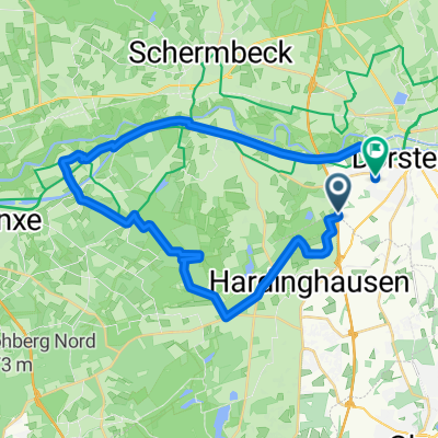
DorBotHünSch(MTB)
A cycling route starting in Dorsten, North Rhine-Westphalia, Germany.
Overview
About this route
Die Tour führt durch vier Gemeinden. Dorsten, Bottrop, Hünxe und Schermbeck. In der Kirchheller Heide durch die Kies- u. Sand Abbaugebiete bis zum Flugplatz "Schwarze Heide". Der "Heidhofsee" der "Heidhof" und der "Heidesee" sind einige Stationen. Dann geht es die "Halde Haniel" hinauf. Im "Hisfelder Wald" geht die Tour durch das "Rotbach Tal". Da die Tour durch gut besuchte Ausflugsgebiete führt, sollte man sie nicht an Sonntagen u. Feiertagen mit schönem Wetter unter die Reifen nehmen.
- -:--
- Duration
- 67.9 km
- Distance
- 254 m
- Ascent
- 253 m
- Descent
- ---
- Avg. speed
- ---
- Avg. speed
Route quality
Waytypes & surfaces along the route
Waytypes
Undefined
67.9 km
(100 %)
Surfaces
Undefined
67.9 km
(100 %)
Route highlights
Points of interest along the route
Point of interest after 18.2 km
Der Kirchheller "Heidesee"
Point of interest after 23.9 km
Die Halde "Haniel"
Point of interest after 29.1 km
Im Rotbachtal
Continue with Bikemap
Use, edit, or download this cycling route
You would like to ride DorBotHünSch(MTB) or customize it for your own trip? Here is what you can do with this Bikemap route:
Free features
- Save this route as favorite or in collections
- Copy & plan your own version of this route
- Sync your route with Garmin or Wahoo
Premium features
Free trial for 3 days, or one-time payment. More about Bikemap Premium.
- Navigate this route on iOS & Android
- Export a GPX / KML file of this route
- Create your custom printout (try it for free)
- Download this route for offline navigation
Discover more Premium features.
Get Bikemap PremiumFrom our community
Other popular routes starting in Dorsten
- DorBotHünSch(MTB)
- Distance
- 67.9 km
- Ascent
- 254 m
- Descent
- 253 m
- Location
- Dorsten, North Rhine-Westphalia, Germany
- Lippe-Tour
- Distance
- 20.5 km
- Ascent
- 30 m
- Descent
- 29 m
- Location
- Dorsten, North Rhine-Westphalia, Germany
- Pilgerroute Etappe 10 Duisburg nach Dorsten
- Distance
- 96.3 km
- Ascent
- 343 m
- Descent
- 342 m
- Location
- Dorsten, North Rhine-Westphalia, Germany
- Hervest Deuten Einrollen
- Distance
- 42.7 km
- Ascent
- 82 m
- Descent
- 82 m
- Location
- Dorsten, North Rhine-Westphalia, Germany
- Kleine Tour durchs Grün
- Distance
- 38 km
- Ascent
- 83 m
- Descent
- 84 m
- Location
- Dorsten, North Rhine-Westphalia, Germany
- 22 - Storchenroute
- Distance
- 23.4 km
- Ascent
- 50 m
- Descent
- 52 m
- Location
- Dorsten, North Rhine-Westphalia, Germany
- Dorsten-Lembeck-Rhade Rundkurs
- Distance
- 44.3 km
- Ascent
- 57 m
- Descent
- 60 m
- Location
- Dorsten, North Rhine-Westphalia, Germany
- Dorsten-Schermbeck-Erle-Heiden-Wulfen-Dorsten CLONED FROM ROUTE 891576
- Distance
- 61.4 km
- Ascent
- 132 m
- Descent
- 134 m
- Location
- Dorsten, North Rhine-Westphalia, Germany