

Breck to A-Basin and back via the dam
A cycling route starting in Breckenridge, Colorado, United States.
Overview
About this route
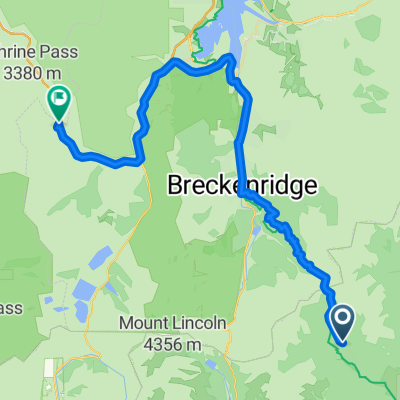
Through the Rocky Mountains of Colorado, you can see 3 fomous skiareas (Breckenridge, keystone and A-Basin). Use the new bikepathes from Swan Mt. Road to Keystone and Keystone to Dillon and Dillon Dam to Frisco.
Turn right on Main Street Frisco to the bike path to Breck.
You will have 800 hm, but you start in an altitude of 2.929m and your going up !!
- -:--
- Duration
- 71.5 km
- Distance
- 884 m
- Ascent
- 886 m
- Descent
- ---
- Avg. speed
- ---
- Max. altitude
Continue with Bikemap
Use, edit, or download this cycling route
You would like to ride Breck to A-Basin and back via the dam or customize it for your own trip? Here is what you can do with this Bikemap route:
Free features
- Save this route as favorite or in collections
- Copy & plan your own version of this route
- Sync your route with Garmin or Wahoo
Premium features
Free trial for 3 days, or one-time payment. More about Bikemap Premium.
- Navigate this route on iOS & Android
- Export a GPX / KML file of this route
- Create your custom printout (try it for free)
- Download this route for offline navigation
Discover more Premium features.
Get Bikemap PremiumFrom our community
Other popular routes starting in Breckenridge
 hoosier
- Distance
- 64.9 km
- Ascent
- 592 m
- Descent
- 817 m
- Location
- Breckenridge, Colorado, United States
 10 at 10 - middle portion
- Distance
- 37.6 km
- Ascent
- 854 m
- Descent
- 1,220 m
- Location
- Breckenridge, Colorado, United States
 Seg13
Seg13- Distance
- 54 km
- Ascent
- 1,393 m
- Descent
- 1,155 m
- Location
- Breckenridge, Colorado, United States
 Fairplay - Frisco
- Distance
- 56.4 km
- Ascent
- 1,326 m
- Descent
- 1,273 m
- Location
- Breckenridge, Colorado, United States
 440 N Park Ave, Breckenridge to 435 N Park Ave, Breckenridge
- Distance
- 52 km
- Ascent
- 624 m
- Descent
- 619 m
- Location
- Breckenridge, Colorado, United States
 Seg12
Seg12- Distance
- 48.1 km
- Ascent
- 1,836 m
- Descent
- 1,735 m
- Location
- Breckenridge, Colorado, United States
 Beck To Copper
- Distance
- 42.6 km
- Ascent
- 1,342 m
- Descent
- 1,296 m
- Location
- Breckenridge, Colorado, United States
 Seg. 13 +Alt
- Distance
- 79.7 km
- Ascent
- 2,056 m
- Descent
- 1,849 m
- Location
- Breckenridge, Colorado, United States
Open it in the app