

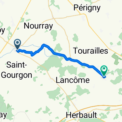
Rue de la République, Saint-Cyr-du-Gault à 17 Rue de Marray, Les Hermites
A cycling route starting in Saint-Amand-Longpré, Centre-Val de Loire, France.
Overview
About this route
- 1 h 10 min
- Duration
- 24.8 km
- Distance
- 141 m
- Ascent
- 143 m
- Descent
- 21.3 km/h
- Avg. speed
- 155 m
- Max. altitude
Route quality
Waytypes & surfaces along the route
Waytypes
Road
23.6 km
(95 %)
Quiet road
0.6 km
(2 %)
Surfaces
Paved
3.5 km
(14 %)
Asphalt
3.5 km
(14 %)
Undefined
21.3 km
(86 %)
Continue with Bikemap
Use, edit, or download this cycling route
You would like to ride Rue de la République, Saint-Cyr-du-Gault à 17 Rue de Marray, Les Hermites or customize it for your own trip? Here is what you can do with this Bikemap route:
Free features
- Save this route as favorite or in collections
- Copy & plan your own version of this route
- Sync your route with Garmin or Wahoo
Premium features
Free trial for 3 days, or one-time payment. More about Bikemap Premium.
- Navigate this route on iOS & Android
- Export a GPX / KML file of this route
- Create your custom printout (try it for free)
- Download this route for offline navigation
Discover more Premium features.
Get Bikemap PremiumFrom our community
Other popular routes starting in Saint-Amand-Longpré
 De Rue du Mai à Rue du Pommier Rond
- Distance
- 15.9 km
- Ascent
- 26 m
- Descent
- 34 m
- Location
- Saint-Amand-Longpré, Centre-Val de Loire, France
 16 Ambloy-Les Bondis
- Distance
- 81 km
- Ascent
- 161 m
- Descent
- 161 m
- Location
- Saint-Amand-Longpré, Centre-Val de Loire, France
 8 Rue du Bourg, Ambloy to 2 Place Jean Jaurès, Tours
- Distance
- 56.1 km
- Ascent
- 298 m
- Descent
- 358 m
- Location
- Saint-Amand-Longpré, Centre-Val de Loire, France
 Rue de la République, Saint-Cyr-du-Gault à 17 Rue de Marray, Les Hermites
- Distance
- 24.8 km
- Ascent
- 141 m
- Descent
- 143 m
- Location
- Saint-Amand-Longpré, Centre-Val de Loire, France
 Villeromain à 221 Grande-Rue, Villeromain
- Distance
- 3 km
- Ascent
- 10 m
- Descent
- 13 m
- Location
- Saint-Amand-Longpré, Centre-Val de Loire, France
 Jour 2 bis
- Distance
- 26.4 km
- Ascent
- 158 m
- Descent
- 213 m
- Location
- Saint-Amand-Longpré, Centre-Val de Loire, France
 jour 2
- Distance
- 36.5 km
- Ascent
- 260 m
- Descent
- 313 m
- Location
- Saint-Amand-Longpré, Centre-Val de Loire, France
 Les Coutières, Villechauve à 5 Place Général de Gaulle, Château-Renault
- Distance
- 8.3 km
- Ascent
- 92 m
- Descent
- 73 m
- Location
- Saint-Amand-Longpré, Centre-Val de Loire, France
Open it in the app