
Leine-Heide-Radweg
A cycling route starting in Göttingen, Lower Saxony, Germany.
Overview
About this route
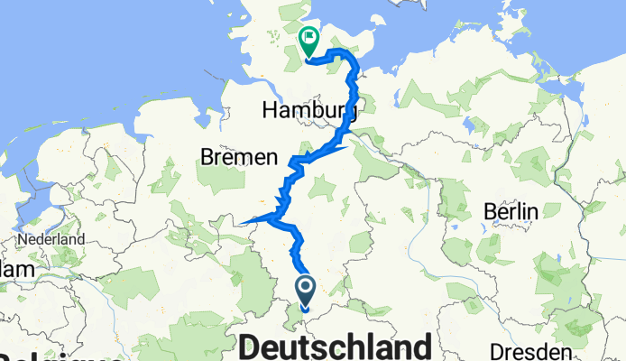
Der Leine-Heide-Radweg verbindet über 400 km die abwechslungsreiche Mittelgebirgslandschaft des Leineberglandes mit der Lüneburger Heide und der Hansestadt Hamburg.
- -:--
- Duration
- 561 km
- Distance
- 1,861 m
- Ascent
- 1,984 m
- Descent
- ---
- Avg. speed
- 170 m
- Avg. speed

Route quality
Waytypes & surfaces along the route
Waytypes
Path
165.3 km
(29 %)
Quiet road
122.4 km
(22 %)
Surfaces
Paved
421.8 km
(75 %)
Unpaved
100.5 km
(18 %)
Asphalt
343.3 km
(61 %)
Gravel
71.9 km
(13 %)
Continue with Bikemap
Use, edit, or download this cycling route
You would like to ride Leine-Heide-Radweg or customize it for your own trip? Here is what you can do with this Bikemap route:
Free features
- Save this route as favorite or in collections
- Copy & plan your own version of this route
- Split it into stages to create a multi-day tour
- Sync your route with Garmin or Wahoo
Premium features
Free trial for 3 days, or one-time payment. More about Bikemap Premium.
- Navigate this route on iOS & Android
- Export a GPX / KML file of this route
- Create your custom printout (try it for free)
- Download this route for offline navigation
Discover more Premium features.
Get Bikemap PremiumFrom our community
Other popular routes starting in Göttingen
 01_2017
- Distance
- 45 km
- Ascent
- 426 m
- Descent
- 426 m
- Location
- Göttingen, Lower Saxony, Germany
 Tour dEnergie 2010 82km (Copy von #351671)
- Distance
- 84.9 km
- Ascent
- 790 m
- Descent
- 883 m
- Location
- Göttingen, Lower Saxony, Germany
 Tour d'Energie 2012 - 100 km
- Distance
- 101.8 km
- Ascent
- 905 m
- Descent
- 897 m
- Location
- Göttingen, Lower Saxony, Germany
 Geismar - Mackenroder Aussichtsturm - Geismar
- Distance
- 26.3 km
- Ascent
- 358 m
- Descent
- 356 m
- Location
- Göttingen, Lower Saxony, Germany
 GÖ-Seeburger See-GÖ
- Distance
- 47.9 km
- Ascent
- 488 m
- Descent
- 429 m
- Location
- Göttingen, Lower Saxony, Germany
 Tour d'Energie von den Terrassen - 46km
- Distance
- 49.3 km
- Ascent
- 527 m
- Descent
- 613 m
- Location
- Göttingen, Lower Saxony, Germany
 Tour d'Energie 2008
- Distance
- 84.7 km
- Ascent
- 944 m
- Descent
- 855 m
- Location
- Göttingen, Lower Saxony, Germany
 GÖ Süd - Deiderode - Atzenhausen - Jühnde - Mengershausen - GÖ Süd
- Distance
- 44.5 km
- Ascent
- 312 m
- Descent
- 312 m
- Location
- Göttingen, Lower Saxony, Germany
Open it in the app