

De Alonso de Benítez 1912, Valdivia a Alonso de Benítez 1912, Valdivia
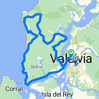
A cycling route starting in Valdivia, Los Ríos Region, Chile.
Overview
About this route
- 1 h 11 min
- Duration
- 19.5 km
- Distance
- 107 m
- Ascent
- 110 m
- Descent
- 16.4 km/h
- Avg. speed
- 26 m
- Max. altitude

Route photos

Route quality
Waytypes & surfaces along the route
Waytypes
Cycleway
4.9 km
(25 %)
Road
3.1 km
(16 %)
Surfaces
Paved
15 km
(77 %)
Unpaved
1.8 km
(9 %)
Paved (undefined)
10.1 km
(52 %)
Asphalt
3.1 km
(16 %)
Continue with Bikemap
Use, edit, or download this cycling route
You would like to ride De Alonso de Benítez 1912, Valdivia a Alonso de Benítez 1912, Valdivia or customize it for your own trip? Here is what you can do with this Bikemap route:
Free features
- Save this route as favorite or in collections
- Copy & plan your own version of this route
- Sync your route with Garmin or Wahoo
Premium features
Free trial for 3 days, or one-time payment. More about Bikemap Premium.
- Navigate this route on iOS & Android
- Export a GPX / KML file of this route
- Create your custom printout (try it for free)
- Download this route for offline navigation
Discover more Premium features.
Get Bikemap PremiumFrom our community
Other popular routes starting in Valdivia
 II Versión "Descubriendo la Selva Valdiviana"
- Distance
- 49.3 km
- Ascent
- 1,044 m
- Descent
- 1,044 m
- Location
- Valdivia, Los Ríos Region, Chile
 III VERSION XTREM DESAFIO GLORIAS DEL EJERCITO
- Distance
- 85.3 km
- Ascent
- 1,357 m
- Descent
- 1,364 m
- Location
- Valdivia, Los Ríos Region, Chile
 La Ruta del Coipo
- Distance
- 20.2 km
- Ascent
- 426 m
- Descent
- 419 m
- Location
- Valdivia, Los Ríos Region, Chile
 Paseo lento en Valdivia
- Distance
- 19.1 km
- Ascent
- 206 m
- Descent
- 200 m
- Location
- Valdivia, Los Ríos Region, Chile
 Ruta liga Inter ciudades Valdivia
- Distance
- 63.3 km
- Ascent
- 1,594 m
- Descent
- 1,529 m
- Location
- Valdivia, Los Ríos Region, Chile
 MEGA SELVA VALDIVIANA
- Distance
- 115.7 km
- Ascent
- 1,062 m
- Descent
- 1,052 m
- Location
- Valdivia, Los Ríos Region, Chile
 Avenida Los Robles 85, Valdivia to Tornagaleones, Valdivia
- Distance
- 18.1 km
- Ascent
- 3 m
- Descent
- 12 m
- Location
- Valdivia, Los Ríos Region, Chile
 Isla Teja circuit
- Distance
- 16.6 km
- Ascent
- 304 m
- Descent
- 305 m
- Location
- Valdivia, Los Ríos Region, Chile
Open it in the app