

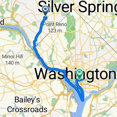
Washington DC nach Clarksville, TN
A cycling route starting in Bethesda, Maryland, United States.
Overview
About this route
In Virginia ist ein Teil der Strecke gut ausgeschildert (TransAmerica BikeRoute 76) ... (wir sind jedoch oftmals auf dem Main Highway geblieben)
Viele freilaufende Hunde auf der Strecke (insbesondere im Westen von Virginia und süd-ost Kentucky) - unbedingt Pfefferspray mitnehmen!!!
- -:--
- Duration
- 1,343.9 km
- Distance
- 1,982 m
- Ascent
- 1,950 m
- Descent
- ---
- Avg. speed
- ---
- Max. altitude
Continue with Bikemap
Use, edit, or download this cycling route
You would like to ride Washington DC nach Clarksville, TN or customize it for your own trip? Here is what you can do with this Bikemap route:
Free features
- Save this route as favorite or in collections
- Copy & plan your own version of this route
- Split it into stages to create a multi-day tour
- Sync your route with Garmin or Wahoo
Premium features
Free trial for 3 days, or one-time payment. More about Bikemap Premium.
- Navigate this route on iOS & Android
- Export a GPX / KML file of this route
- Create your custom printout (try it for free)
- Download this route for offline navigation
Discover more Premium features.
Get Bikemap PremiumFrom our community
Other popular routes starting in Bethesda
 Twinbrook Loop
- Distance
- 25.5 km
- Ascent
- 160 m
- Descent
- 161 m
- Location
- Bethesda, Maryland, United States
 2020-08-02
- Distance
- 26.9 km
- Ascent
- 181 m
- Descent
- 184 m
- Location
- Bethesda, Maryland, United States
 Woodmont Avenue to Nebraska Avenue Northwest
- Distance
- 12.7 km
- Ascent
- 141 m
- Descent
- 178 m
- Location
- Bethesda, Maryland, United States
 Bethesda - Smithsonian
- Distance
- 24.9 km
- Ascent
- 136 m
- Descent
- 236 m
- Location
- Bethesda, Maryland, United States
 Long ride from Chevy Chase to Silver Spring
- Distance
- 52 km
- Ascent
- 227 m
- Descent
- 239 m
- Location
- Bethesda, Maryland, United States
 Rock Creek Trail
- Distance
- 7.2 km
- Ascent
- 58 m
- Descent
- 96 m
- Location
- Bethesda, Maryland, United States
 Washington DC nach Clarksville, TN
- Distance
- 1,343.9 km
- Ascent
- 1,982 m
- Descent
- 1,950 m
- Location
- Bethesda, Maryland, United States
 Cabin John/C&O/Capitol Crescent
- Distance
- 33.4 km
- Ascent
- 172 m
- Descent
- 181 m
- Location
- Bethesda, Maryland, United States
Open it in the app