
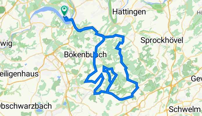
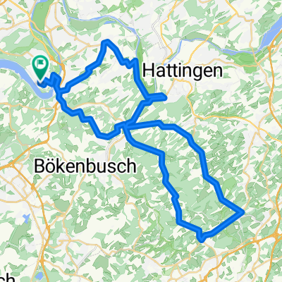
56 km ^840 hm (875 hm?)
A cycling route starting in Velbert, North Rhine-Westphalia, Germany.
Overview
About this route
HAC: 56 km, 2:52 h, 753 hm.
- -:--
- Duration
- 58.3 km
- Distance
- 875 m
- Ascent
- 879 m
- Descent
- ---
- Avg. speed
- 306 m
- Avg. speed

Route quality
Waytypes & surfaces along the route
Waytypes
Road
16.6 km
(29 %)
Busy road
16.2 km
(28 %)
Surfaces
Paved
52.8 km
(91 %)
Unpaved
0.4 km
(<1 %)
Asphalt
52.4 km
(90 %)
Gravel
0.3 km
(<1 %)
Continue with Bikemap
Use, edit, or download this cycling route
You would like to ride 56 km ^840 hm (875 hm?) or customize it for your own trip? Here is what you can do with this Bikemap route:
Free features
- Save this route as favorite or in collections
- Copy & plan your own version of this route
- Sync your route with Garmin or Wahoo
Premium features
Free trial for 3 days, or one-time payment. More about Bikemap Premium.
- Navigate this route on iOS & Android
- Export a GPX / KML file of this route
- Create your custom printout (try it for free)
- Download this route for offline navigation
Discover more Premium features.
Get Bikemap PremiumFrom our community
Other popular routes starting in Velbert
 Tiergarten 32, Essen to Tiergarten 32, Essen
- Distance
- 17 km
- Ascent
- 66 m
- Descent
- 68 m
- Location
- Velbert, North Rhine-Westphalia, Germany
 Hösel-Bergerhof-Hösel
- Distance
- 75.6 km
- Ascent
- 719 m
- Descent
- 719 m
- Location
- Velbert, North Rhine-Westphalia, Germany
 4-Berge-Tour: Heisingen-Elfringhauser Schweiz-Heisingen
- Distance
- 49.8 km
- Ascent
- 562 m
- Descent
- 568 m
- Location
- Velbert, North Rhine-Westphalia, Germany
 Trassen und Sprockhövel
- Distance
- 60.4 km
- Ascent
- 460 m
- Descent
- 460 m
- Location
- Velbert, North Rhine-Westphalia, Germany
 Flughafen-Tour
- Distance
- 62 km
- Ascent
- 369 m
- Descent
- 369 m
- Location
- Velbert, North Rhine-Westphalia, Germany
 Auftakt Stadtradeln Velbert kurz 2
- Distance
- 26.5 km
- Ascent
- 228 m
- Descent
- 229 m
- Location
- Velbert, North Rhine-Westphalia, Germany
 Fischlaken-Hespertal-Bleiberg-UntEickeshagen-Senderberg-Dönberg-Wodantal-Kupferdreh-Maasstrasse
- Distance
- 56.7 km
- Ascent
- 789 m
- Descent
- 843 m
- Location
- Velbert, North Rhine-Westphalia, Germany
 Radrunde im Essener Süden - Radrunde im Essener Süden
- Distance
- 31.1 km
- Ascent
- 323 m
- Descent
- 322 m
- Location
- Velbert, North Rhine-Westphalia, Germany
Open it in the app