
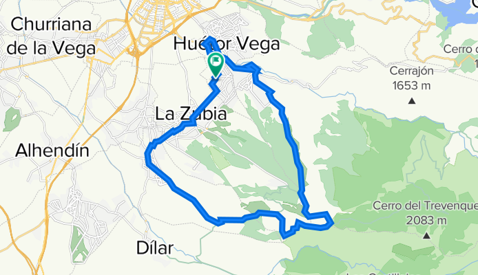
Cajar - Canal de la Espartera - Gojar - Cajar
A cycling route starting in Cájar, Andalusia, Spain.
Overview
About this route
Spectacular route up to the Espartera canal.
The ascent was made via Colina Bermejas to the Hervidero fountain and the canal.
To descend, a path was taken to Gojar.
- -:--
- Duration
- 27.5 km
- Distance
- 704 m
- Ascent
- 706 m
- Descent
- ---
- Avg. speed
- ---
- Max. altitude

Continue with Bikemap
Use, edit, or download this cycling route
You would like to ride Cajar - Canal de la Espartera - Gojar - Cajar or customize it for your own trip? Here is what you can do with this Bikemap route:
Free features
- Save this route as favorite or in collections
- Copy & plan your own version of this route
- Sync your route with Garmin or Wahoo
Premium features
Free trial for 3 days, or one-time payment. More about Bikemap Premium.
- Navigate this route on iOS & Android
- Export a GPX / KML file of this route
- Create your custom printout (try it for free)
- Download this route for offline navigation
Discover more Premium features.
Get Bikemap PremiumFrom our community
Other popular routes starting in Cájar
 Cajar - Llano de la Perdiz - Sacromonte - Cajar
- Distance
- 33.8 km
- Ascent
- 448 m
- Descent
- 446 m
- Location
- Cájar, Andalusia, Spain
 Cajar - Quentar - Canales
- Distance
- 50.5 km
- Ascent
- 682 m
- Descent
- 684 m
- Location
- Cájar, Andalusia, Spain
 Cajar - Ermita Vieja - Marchena - Otura - Cajar
- Distance
- 52.4 km
- Ascent
- 983 m
- Descent
- 981 m
- Location
- Cájar, Andalusia, Spain
 Cajar - Otura - Puntal - Armilla - Cajar
- Distance
- 40.5 km
- Ascent
- 350 m
- Descent
- 352 m
- Location
- Cájar, Andalusia, Spain
 Huetor Vega - Monachil - El Purche - El Duque - Pradollano - Descenso A395 - Cenes - Granada
- Distance
- 86.3 km
- Ascent
- 2,192 m
- Descent
- 2,209 m
- Location
- Cájar, Andalusia, Spain
 Cajar- Almuñecar
- Distance
- 78.4 km
- Ascent
- 1,413 m
- Descent
- 2,192 m
- Location
- Cájar, Andalusia, Spain
 Cajar - Pradollano
- Distance
- 36.5 km
- Ascent
- 1,455 m
- Descent
- 69 m
- Location
- Cájar, Andalusia, Spain
 Cajar - Canal de la Espartera - Gojar - Cajar
- Distance
- 27.5 km
- Ascent
- 704 m
- Descent
- 706 m
- Location
- Cájar, Andalusia, Spain
Open it in the app