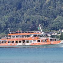
- 86.8 km
- 675 m
- 676 m
- Klagenfurt, Carinthia, Austria
MTB-Trail: KLU-Falkenberg(ScoobyTrail)-Feschnig-St.GeorgenAmSadhof-MariaSaalerBerg(BaroninTrail)-Terndorf-Feschnig-Falkenberg-Zillhöhe-KLU
A cycling route starting in Klagenfurt, Carinthia, Austria.
Overview
About this route
MTB Trail: KLU-Falkenberg (ScoobyTrail) - Feschnig - St.GeorgenAmSadhof - MariaSaalerBerg (BaroninTrail) - Terndorf - Feschnig - Falkenberg - Zillhöhe - KLU
Maria Saaler Berg: https://www.trailforks.com/region/maria-saaler-berg-trails-56608/
- -:--
- Duration
- 32.8 km
- Distance
- 862 m
- Ascent
- 859 m
- Descent
- ---
- Avg. speed
- 743 m
- Max. altitude
created this 2 years ago
Route quality
Waytypes & surfaces along the route
Waytypes
Track
10.5 km
(32 %)
Quiet road
10.2 km
(31 %)
Surfaces
Paved
13.8 km
(42 %)
Unpaved
9.5 km
(29 %)
Asphalt
13.5 km
(41 %)
Ground
7.2 km
(22 %)
Continue with Bikemap
Use, edit, or download this cycling route
You would like to ride MTB-Trail: KLU-Falkenberg(ScoobyTrail)-Feschnig-St.GeorgenAmSadhof-MariaSaalerBerg(BaroninTrail)-Terndorf-Feschnig-Falkenberg-Zillhöhe-KLU or customize it for your own trip? Here is what you can do with this Bikemap route:
Free features
- Save this route as favorite or in collections
- Copy & plan your own version of this route
- Sync your route with Garmin or Wahoo
Premium features
Free trial for 3 days, or one-time payment. More about Bikemap Premium.
- Navigate this route on iOS & Android
- Export a GPX / KML file of this route
- Create your custom printout (try it for free)
- Download this route for offline navigation
Discover more Premium features.
Get Bikemap PremiumFrom our community
Other popular routes starting in Klagenfurt
- Ironman Strecke
- Wörtherseerunde (55 km ) Klagenfurt, Seenrunde, Velden retour.
- 54.6 km
- 494 m
- 492 m
- Klagenfurt, Carinthia, Austria
- Klagenfurt
- 15.1 km
- 55 m
- 97 m
- Klagenfurt, Carinthia, Austria
- MTB-Trail: KLU-Falkenberg(ScoobyTrail)-Feschnig-St.GeorgenAmSadhof-MariaSaalerBerg(BaroninTrail)-Terndorf-Feschnig-Falkenberg-Zillhöhe-KLU
- 32.8 km
- 862 m
- 859 m
- Klagenfurt, Carinthia, Austria
- zur Gurkmündung
- 54 km
- 143 m
- 143 m
- Klagenfurt, Carinthia, Austria
- Theodor-Prosen-Gasse, Klagenfurt am Wörthersee nach Wörthersee-Südufer-Straße, Klagenfurt am Wörthersee
- 49.8 km
- 429 m
- 432 m
- Klagenfurt, Carinthia, Austria
- Klagenfurt-Mountainbike-Tour keine Wasserfälle
- 20 km
- 275 m
- 114 m
- Klagenfurt, Carinthia, Austria
- österreich
- 1,232.5 km
- 11,705 m
- 11,751 m
- Klagenfurt, Carinthia, Austria
Open it in the app


