

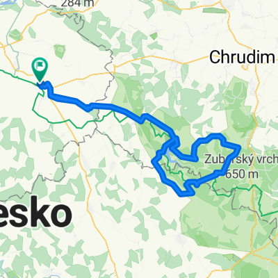
56 km
A cycling route starting in Čáslav, Central Bohemia, Czechia.
Overview
About this route
Čím více zde napíšete informací, tím více bude užitečnější pro ostatním uživatele.<br /><br />* Průběh trasy.<br />* Co je zvláštní na této trase?<br />* Proč doporučit tuto trasu?<br />* Co se Vám zde nejvíce líbilo?<br />* Atd.
- -:--
- Duration
- 55.7 km
- Distance
- 316 m
- Ascent
- 305 m
- Descent
- ---
- Avg. speed
- ---
- Max. altitude

Route quality
Waytypes & surfaces along the route
Waytypes
Road
25 km
(45 %)
Busy road
25 km
(45 %)
Surfaces
Paved
7.7 km
(14 %)
Unpaved
0.9 km
(2 %)
Asphalt
7.7 km
(14 %)
Gravel
0.6 km
(1 %)
Continue with Bikemap
Use, edit, or download this cycling route
You would like to ride 56 km or customize it for your own trip? Here is what you can do with this Bikemap route:
Free features
- Save this route as favorite or in collections
- Copy & plan your own version of this route
- Sync your route with Garmin or Wahoo
Premium features
Free trial for 3 days, or one-time payment. More about Bikemap Premium.
- Navigate this route on iOS & Android
- Export a GPX / KML file of this route
- Create your custom printout (try it for free)
- Download this route for offline navigation
Discover more Premium features.
Get Bikemap PremiumFrom our community
Other popular routes starting in Čáslav
 Čáslav - Vrdy - Vynaře - Starkoč - Čáslav
- Distance
- 29.1 km
- Ascent
- 136 m
- Descent
- 136 m
- Location
- Čáslav, Central Bohemia, Czechia
 63 km Kladruby
- Distance
- 63.5 km
- Ascent
- 248 m
- Descent
- 233 m
- Location
- Čáslav, Central Bohemia, Czechia
 65 km heř - seč
- Distance
- 64.9 km
- Ascent
- 568 m
- Descent
- 560 m
- Location
- Čáslav, Central Bohemia, Czechia
 82 km zvl
- Distance
- 81.9 km
- Ascent
- 365 m
- Descent
- 346 m
- Location
- Čáslav, Central Bohemia, Czechia
 56 km
56 km- Distance
- 55.7 km
- Ascent
- 316 m
- Descent
- 305 m
- Location
- Čáslav, Central Bohemia, Czechia
 96 kopce Seč
- Distance
- 96.3 km
- Ascent
- 965 m
- Descent
- 965 m
- Location
- Čáslav, Central Bohemia, Czechia
 Caslav - Tisa skala
- Distance
- 8.5 km
- Ascent
- 146 m
- Descent
- 28 m
- Location
- Čáslav, Central Bohemia, Czechia
 Chotusice - St. Kolín - Červené Pečky - Kutná Hora - Chotusice
- Distance
- 51.9 km
- Ascent
- 324 m
- Descent
- 324 m
- Location
- Čáslav, Central Bohemia, Czechia
Open it in the app