

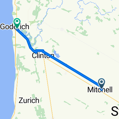
winthrop to covered bridge 147
A cycling route starting in Huron East, Ontario, Canada.
Overview
About this route
7 more km towards blyht to get the century
- -:--
- Duration
- 147.5 km
- Distance
- 425 m
- Ascent
- 425 m
- Descent
- ---
- Avg. speed
- 406 m
- Max. altitude

Route quality
Waytypes & surfaces along the route
Waytypes
Cycleway
73.8 km
(50 %)
Path
50.2 km
(34 %)
Surfaces
Paved
17.7 km
(12 %)
Unpaved
100.3 km
(68 %)
Loose gravel
70.8 km
(48 %)
Unpaved (undefined)
29.5 km
(20 %)
Continue with Bikemap
Use, edit, or download this cycling route
You would like to ride winthrop to covered bridge 147 or customize it for your own trip? Here is what you can do with this Bikemap route:
Free features
- Save this route as favorite or in collections
- Copy & plan your own version of this route
- Split it into stages to create a multi-day tour
- Sync your route with Garmin or Wahoo
Premium features
Free trial for 3 days, or one-time payment. More about Bikemap Premium.
- Navigate this route on iOS & Android
- Export a GPX / KML file of this route
- Create your custom printout (try it for free)
- Download this route for offline navigation
Discover more Premium features.
Get Bikemap PremiumFrom our community
Other popular routes starting in Huron East
 G2G Walton to Moncton and back
- Distance
- 41 km
- Ascent
- 71 m
- Descent
- 68 m
- Location
- Huron East, Ontario, Canada
 Mom and Als
- Distance
- 54.7 km
- Ascent
- 109 m
- Descent
- 227 m
- Location
- Huron East, Ontario, Canada
 Mitchell Loop 1
- Distance
- 9.5 km
- Ascent
- 22 m
- Descent
- 24 m
- Location
- Huron East, Ontario, Canada
 Mom and Als
- Distance
- 63.8 km
- Ascent
- 139 m
- Descent
- 258 m
- Location
- Huron East, Ontario, Canada
 Perth Road 135 and back
- Distance
- 26.2 km
- Ascent
- 41 m
- Descent
- 40 m
- Location
- Huron East, Ontario, Canada
 nice 69
- Distance
- 68.8 km
- Ascent
- 205 m
- Descent
- 203 m
- Location
- Huron East, Ontario, Canada
 Ride to Goderich
- Distance
- 115.9 km
- Ascent
- 1,525 m
- Descent
- 1,447 m
- Location
- Huron East, Ontario, Canada
 Morris-Turnberry to Barrel Yards Blvd, Waterloo
- Distance
- 90.8 km
- Ascent
- 278 m
- Descent
- 286 m
- Location
- Huron East, Ontario, Canada
Open it in the app