
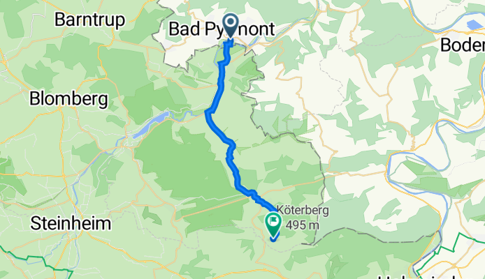
Hauptmann-Bölke-Straße 3, Bad Pyrmont - Köterbergstraße 24, Lügde
A cycling route starting in Bad Pyrmont, Lower Saxony, Germany.
Overview
About this route
- 1 h 9 min
- Duration
- 17.6 km
- Distance
- 239 m
- Ascent
- 77 m
- Descent
- 15.2 km/h
- Avg. speed
- 332 m
- Avg. speed

Route quality
Waytypes & surfaces along the route
Waytypes
Path
5.4 km
(31 %)
Quiet road
3.5 km
(20 %)
Surfaces
Paved
16.7 km
(95 %)
Unpaved
0.2 km
(1 %)
Asphalt
12.8 km
(73 %)
Paved (undefined)
2.3 km
(13 %)
Continue with Bikemap
Use, edit, or download this cycling route
You would like to ride Hauptmann-Bölke-Straße 3, Bad Pyrmont - Köterbergstraße 24, Lügde or customize it for your own trip? Here is what you can do with this Bikemap route:
Free features
- Save this route as favorite or in collections
- Copy & plan your own version of this route
- Sync your route with Garmin or Wahoo
Premium features
Free trial for 3 days, or one-time payment. More about Bikemap Premium.
- Navigate this route on iOS & Android
- Export a GPX / KML file of this route
- Create your custom printout (try it for free)
- Download this route for offline navigation
Discover more Premium features.
Get Bikemap PremiumFrom our community
Other popular routes starting in Bad Pyrmont
 Von Pyrmont nach Plön und nach Pyrmont zurück
- Distance
- 740.7 km
- Ascent
- 622 m
- Descent
- 637 m
- Location
- Bad Pyrmont, Lower Saxony, Germany
 Holzhausen-Meinte-Eschenbruch-Hagen-Holzhausen
- Distance
- 28.3 km
- Ascent
- 476 m
- Descent
- 471 m
- Location
- Bad Pyrmont, Lower Saxony, Germany
 Bad Pyrmont-Ostwestfalenstraße-Köterberg
- Distance
- 86.1 km
- Ascent
- 757 m
- Descent
- 757 m
- Location
- Bad Pyrmont, Lower Saxony, Germany
 Bad Pyrmont - Hannover
- Distance
- 91.8 km
- Ascent
- 600 m
- Descent
- 652 m
- Location
- Bad Pyrmont, Lower Saxony, Germany
 Halbe Runde um Bad Pyrmont
- Distance
- 30.8 km
- Ascent
- 444 m
- Descent
- 443 m
- Location
- Bad Pyrmont, Lower Saxony, Germany
 21 km Bad Pyrmont Waldweg
- Distance
- 21.9 km
- Ascent
- 478 m
- Descent
- 483 m
- Location
- Bad Pyrmont, Lower Saxony, Germany
 Langer Grund-Schellenturm-Hagen -Holzhausen August 2013
- Distance
- 26.7 km
- Ascent
- 441 m
- Descent
- 437 m
- Location
- Bad Pyrmont, Lower Saxony, Germany
 Skinfit Tour 1 (Um die Hochebene)
- Distance
- 68.7 km
- Ascent
- 388 m
- Descent
- 398 m
- Location
- Bad Pyrmont, Lower Saxony, Germany
Open it in the app