

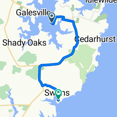
5570 W Shady Side Rd, Churchton to 5570 W Shady Side Rd, Churchton
A cycling route starting in Shady Side, Maryland, United States.
Overview
About this route
- 1 h 49 min
- Duration
- 30.7 km
- Distance
- 205 m
- Ascent
- 207 m
- Descent
- 16.9 km/h
- Avg. speed
- 62 m
- Max. altitude

Route quality
Waytypes & surfaces along the route
Waytypes
Quiet road
21.6 km
(71 %)
Busy road
4.4 km
(14 %)
Surfaces
Paved
20.3 km
(66 %)
Asphalt
20.2 km
(66 %)
Concrete
0.1 km
(<1 %)
Undefined
10.4 km
(34 %)
Continue with Bikemap
Use, edit, or download this cycling route
You would like to ride 5570 W Shady Side Rd, Churchton to 5570 W Shady Side Rd, Churchton or customize it for your own trip? Here is what you can do with this Bikemap route:
Free features
- Save this route as favorite or in collections
- Copy & plan your own version of this route
- Sync your route with Garmin or Wahoo
Premium features
Free trial for 3 days, or one-time payment. More about Bikemap Premium.
- Navigate this route on iOS & Android
- Export a GPX / KML file of this route
- Create your custom printout (try it for free)
- Download this route for offline navigation
Discover more Premium features.
Get Bikemap PremiumFrom our community
Other popular routes starting in Shady Side
 Hine Drive 4946, Shady Side to Exeter Street 5545, Deale
- Distance
- 9.1 km
- Ascent
- 54 m
- Descent
- 52 m
- Location
- Shady Side, Maryland, United States
 Slow ride in West River
- Distance
- 4.4 km
- Ascent
- 0 m
- Descent
- 5 m
- Location
- Shady Side, Maryland, United States
 5570 W Shady Side Rd, Churchton to 5570 W Shady Side Rd, Churchton
- Distance
- 30.7 km
- Ascent
- 205 m
- Descent
- 207 m
- Location
- Shady Side, Maryland, United States
 Hine Drive 4943, Shady Side to South Creek View Court 5170, Shady Side
- Distance
- 6 km
- Ascent
- 41 m
- Descent
- 38 m
- Location
- Shady Side, Maryland, United States
 Hine Drive 4946, Shady Side to East Chalk Point Road 4925, West River
- Distance
- 8.7 km
- Ascent
- 34 m
- Descent
- 34 m
- Location
- Shady Side, Maryland, United States
 Hine Drive 4950, Shady Side to Bayview Parkway 5723, Deale
- Distance
- 9 km
- Ascent
- 64 m
- Descent
- 61 m
- Location
- Shady Side, Maryland, United States
 Terrel Drive 4943, Shady Side to Deep Cove Road 1199, Shady Side
- Distance
- 5.5 km
- Ascent
- 35 m
- Descent
- 34 m
- Location
- Shady Side, Maryland, United States
 Home to Deale
- Distance
- 15.2 km
- Ascent
- 36 m
- Descent
- 35 m
- Location
- Shady Side, Maryland, United States
Open it in the app