
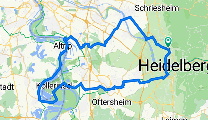
HD-Kollerfähre-Altrip-HD
A cycling route starting in Dossenheim, Baden-Württemberg, Germany.
Overview
About this route
- -:--
- Duration
- 54.4 km
- Distance
- 169 m
- Ascent
- 170 m
- Descent
- ---
- Avg. speed
- 120 m
- Avg. speed
Route quality
Waytypes & surfaces along the route
Waytypes
Track
13.1 km
(24 %)
Path
13.1 km
(24 %)
Surfaces
Paved
50.5 km
(93 %)
Unpaved
0.9 km
(2 %)
Asphalt
44.5 km
(82 %)
Paved (undefined)
4 km
(7 %)
Continue with Bikemap
Use, edit, or download this cycling route
You would like to ride HD-Kollerfähre-Altrip-HD or customize it for your own trip? Here is what you can do with this Bikemap route:
Free features
- Save this route as favorite or in collections
- Copy & plan your own version of this route
- Sync your route with Garmin or Wahoo
Premium features
Free trial for 3 days, or one-time payment. More about Bikemap Premium.
- Navigate this route on iOS & Android
- Export a GPX / KML file of this route
- Create your custom printout (try it for free)
- Download this route for offline navigation
Discover more Premium features.
Get Bikemap PremiumFrom our community
Other popular routes starting in Dossenheim
 Flache 50km Dossenheim-Viernheim
- Distance
- 52.2 km
- Ascent
- 20 m
- Descent
- 26 m
- Location
- Dossenheim, Baden-Württemberg, Germany
 Über's Mühltal auf den Hohen Nistler
- Distance
- 14.6 km
- Ascent
- 493 m
- Descent
- 492 m
- Location
- Dossenheim, Baden-Württemberg, Germany
 Odenwald Runde
- Distance
- 60.2 km
- Ascent
- 1,119 m
- Descent
- 1,119 m
- Location
- Dossenheim, Baden-Württemberg, Germany
 Rennstrecke Weisser Stein
- Distance
- 5.3 km
- Ascent
- 396 m
- Descent
- 118 m
- Location
- Dossenheim, Baden-Württemberg, Germany
 Mannheim Dossenheim
- Distance
- 40.2 km
- Ascent
- 20 m
- Descent
- 20 m
- Location
- Dossenheim, Baden-Württemberg, Germany
 Triple-X
- Distance
- 56.7 km
- Ascent
- 1,846 m
- Descent
- 1,847 m
- Location
- Dossenheim, Baden-Württemberg, Germany
 Heidelberg - Odenwaldrunde
- Distance
- 100.6 km
- Ascent
- 1,560 m
- Descent
- 1,554 m
- Location
- Dossenheim, Baden-Württemberg, Germany
 Thingstätte
- Distance
- 14.4 km
- Ascent
- 497 m
- Descent
- 497 m
- Location
- Dossenheim, Baden-Württemberg, Germany
Open it in the app