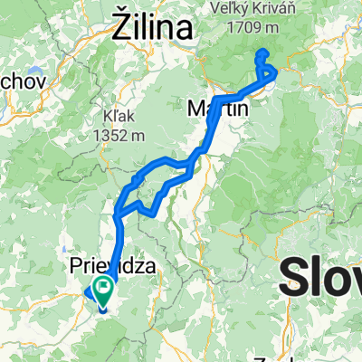
Dubinky 4 do Dubinky 4
A cycling route starting in Nováky, Nitra Region, Slovakia.
Overview
About this route
- 54 min
- Duration
- 20.1 km
- Distance
- 160 m
- Ascent
- 160 m
- Descent
- 22.4 km/h
- Avg. speed
- 386 m
- Max. altitude
Route quality
Waytypes & surfaces along the route
Waytypes
Road
8.6 km
(43 %)
Busy road
5.8 km
(29 %)
Surfaces
Paved
5 km
(25 %)
Asphalt
5 km
(25 %)
Undefined
15.1 km
(75 %)
Continue with Bikemap
Use, edit, or download this cycling route
You would like to ride Dubinky 4 do Dubinky 4 or customize it for your own trip? Here is what you can do with this Bikemap route:
Free features
- Save this route as favorite or in collections
- Copy & plan your own version of this route
- Sync your route with Garmin or Wahoo
Premium features
Free trial for 3 days, or one-time payment. More about Bikemap Premium.
- Navigate this route on iOS & Android
- Export a GPX / KML file of this route
- Create your custom printout (try it for free)
- Download this route for offline navigation
Discover more Premium features.
Get Bikemap PremiumFrom our community
Other popular routes starting in Nováky
- JPL doplnok k veľkej "parenici"
- Distance
- 7.8 km
- Ascent
- 170 m
- Descent
- 620 m
- Location
- Nováky, Nitra Region, Slovakia
- Lehota-D.Vestenice-K.Luky-N.Sucany-Lehota
- Distance
- 58 km
- Ascent
- 1,026 m
- Descent
- 1,026 m
- Location
- Nováky, Nitra Region, Slovakia
- Lehota-Kamenec-Vtacnik-Jaraba skala-nad Ciglom-Podhradie-Lehota
- Distance
- 39.9 km
- Ascent
- 1,211 m
- Descent
- 1,212 m
- Location
- Nováky, Nitra Region, Slovakia
- Lehotská 143 do Partizánska 47
- Distance
- 18.5 km
- Ascent
- 755 m
- Descent
- 630 m
- Location
- Nováky, Nitra Region, Slovakia
- Lehota-Cigel-Novaky-Lehota
- Distance
- 28.3 km
- Ascent
- 402 m
- Descent
- 403 m
- Location
- Nováky, Nitra Region, Slovakia
- na Vtacnik
- Distance
- 33.9 km
- Ascent
- 1,091 m
- Descent
- 1,090 m
- Location
- Nováky, Nitra Region, Slovakia
- Vtacnik_22-8-2018
- Distance
- 32.9 km
- Ascent
- 1,066 m
- Descent
- 1,066 m
- Location
- Nováky, Nitra Region, Slovakia
- Naucny bansky turisticky chodnik
- Distance
- 15.1 km
- Ascent
- 249 m
- Descent
- 249 m
- Location
- Nováky, Nitra Region, Slovakia
Open it in the app